place

Bowen Island

1999 establishments in British ColumbiaBowen IslandIsland municipalities in British ColumbiaIslands of British ColumbiaPopulated places in Greater Vancouver
South Coast of British ColumbiaUse Canadian English from January 2023
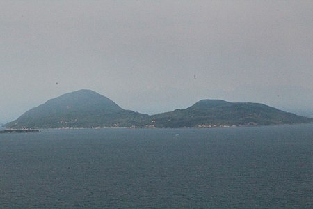
Bowen Island from water

Bowen Island (originally Nex̱wlélex̱wm in Sḵwx̱wú7mesh), British Columbia, is an island municipality that is part of Metro Vancouver, and within the jurisdiction of the Islands Trust. Located in Howe Sound, it is approximately 6 kilometres (3.7 mi) wide by 12 kilometres (7.5 mi) long, and at its closest point is about 3 kilometres (1.9 mi) west of the mainland. There is regular ferry service from Horseshoe Bay provided by BC Ferries, and semi-regular water taxi services. The population of 4,256 is supplemented in the summer by about 1,500 visitors. It has a land area of 50.12 km2 (19.35 sq mi).

Excerpt from the Wikipedia article Bowen Island (License: CC BY-SA 3.0, Authors, Images).

Bowen Island
Easy Street, Bowen Island Municipality

Geographical coordinates (GPS) Address Nearby Places
placeShow on map

Wikipedia: Bowen IslandContinue reading on Wikipedia

Geographical coordinates (GPS)

Latitude Longitude
N 49.383333333333 ° E -123.38333333333 °
placeShow on map

Address

Easy Street

Easy Street
V0N 1G0 Bowen Island Municipality
British Columbia, Canada
mapOpen on Google Maps

Bowen Island from water
Share experience

Nearby Places

Plumper Cove Marine Provincial Park

Plumper Cove Marine Provincial Park is a provincial park in British Columbia, Canada. The park is located on Keats Island in Howe Sound, northwest of Vancouver, British Columbia. It is one of the oldest marine parks on the BC coast, and a popular anchorage in the summer months. The 57-hectare park is located on the northwest shore of Keats Island. The park has a well maintained hiking trail system, a grassy upland picnic area and forested walk-in campsites. The trail system consists of 'Keats Loop' which leads to the top of a bluff to a lookout, and then there is a 2 km (1 mi) trail which leads to Keats' Landing, the final segment of which can be travelled either by dirt road or trail. The 2 km (1 mi) trail is of intermediate level, easy to hike when not laden with camping gear, but somewhat arduous when hiking in with several days worth of camping supplies. It is roughly 1 km (1 mi) uphill and 1 km (1 mi) downhill either direction, and somewhat near the trail's middle it peaks near the lookout. There are only two ways for the public to access the park; by marine access or by hiking in. Travellers can take BC Ferries from Horseshoe Bay to Langdale, then board the Stornaway II which makes infrequent trips to Keats' Island and Gambier Island, then hike roughly 2 km (1 mi) to the campground. The trail from Keats Landing to Plumper Cove Marine Park is NOT bike friendly, and most trails on the island are similarly challenging - bicycles are not recommended but good walking shoes will get you where you need to go! Alternately, via marine access, one with their own boat can navigate and pay moorage fees at the park dock. Several water taxi services are available from Gibsons to Plumper Cove Marine Park, but these are somewhat erratic and do not operate on a regular schedule, sometimes requiring a charter. The park is known for its quiet and natural surroundings. Unlike many other provincial campgrounds which have vehicle access, traffic by locals there to drink and make loud noise is limited. Occasionally people from Gibsons, British Columbia or those who have cabins on Keats Island will park a barge or tie together a series of boats and have a private flotilla party, although this is rare and usually only occurs on peak long weekends. Due to the natural surroundings, lack of vehicle access, and dedication or investment in a marine vehicle to get to the park, the park is lovingly referred to by those who frequent it regularly as "the best campground in BC". Those from Vancouver, British Columbia who frequent the park tend to go back every year on the same weekends at the same time, and tend to not advertise to their fellow city dwellers about the park in order to keep it private and from it getting too busy. From September 24 to May 15, the park does not charge camping fees, but has limited services available. Normally, during peak summer months, the camping fee is $16 per night per party (party up to four). There are group campsites available which are double sites for larger parties. Group picknicking services are available by private reservation only. Moorage at a buoy costs $12 per night, and moorage at the dock costs $2.00 per metre per night. Docking and moorage fees only apply after 6pm. During the winter months most services are free of charge. Garbage service is very limited (if at all) and visitors should plan to pack out anything they may bring. The park has potable water available from a hand pump only from May 15th to Sep 15th and the pit toilets are open year around. Due to storm damage in the winter of 2006 the dock at the Park was destroyed, and replaced in 2007.
Passage Island (British Columbia)

Passage Island is a small island near West Vancouver, British Columbia, and across from Bowen Island in Canada. The island is mostly woodland and cliffs. It marks the entrance to Howe Sound, and the ferry between Horseshoe Bay to Nanaimo regularly passes it. The island borrows a postal code, V7W 1V7, from the wealthiest community in Canada, West Vancouver. However, Passage Island is actually overseen by the Islands Trust and is part of the Metro Vancouver Regional District. It is isolated from West Vancouver by approximately two km (1.2 mi) of ocean. Prior to European colonization, the island was home to a Squamish village named Mi'tlmetle'lte. It was named by Captain Vancouver for the fact that it lies midway between Point Atkinson and Bowen Island, in the Queen Charlotte Channel.: 202 In 1893, the island was sold for a dollar an acre by a banker named Keith, and was later bought in the late 1960s by a developer named Phil Matty. "No utilities, no garbage trucks, no telephones, no fire stations, no policemen, no industry—just 32 acres of beautiful British Columbia. I escaped to that paradise for a few hours each week to move rocks, saw logs, watch the tide come in and go out—all in the name of therapeutic basket weaving. It was like having my own personal psychiatrist. I loved it. I loved it so much that I bought it."Today the island has 61 lots, almost half of which are developed. Although many lots consist of summer cottages, there are a few year-round homes with full-time residents. The island has views of downtown Vancouver, the University of British Columbia campus, Vancouver Island, and the snow-capped mountains of Howe Sound. There are no developed roads nor vehicles on the island. Most of the homes use solar photovoltaics, with a few complemented by wind turbines for electric power. Propane is used for heating and cooking, and rainwater is captured into cisterns from their roofs. Island residents either tie their boats to mooring buoys and row to shore, or provide their own private docks for island access. Public access onto the island is not provided. Off the southernmost tip is a small private island. Unnamed, the island is owned by a local family.