place

Brechhorn

Kitzbühel AlpsMountains of Tyrol (state)Mountains of the AlpsTwo-thousanders of Austria
Brechhorn ridge
Brechhorn ridge

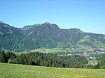
The Brechhorn is a 2,032 m above sea level (AA) high mountain in the Kitzbühel Alps in Austria. It lies between the valleys of the Aschauer Ache and the Windau.

Excerpt from the Wikipedia article Brechhorn (License: CC BY-SA 3.0, Authors, Images).

Geographical coordinates (GPS)

Latitude Longitude
N 47.3779528 ° E 12.265806 °
placeShow on map

Address

Oberwindau 187
6363
Tyrol, Austria
mapOpen on Google Maps

Brechhorn ridge
Brechhorn ridge
Share experience

Nearby Places

Windautal
Windautal

The Windautal is a southern side valley of the Tyrolean Brixental in the Kitzbühel Alps in Austria with a length of about 16 km. The valley is lies almost entirely within the territory of the parish of Westendorf; only its northernmost part lies in Hopfgarten. To the south the valley borders on the state of Salzburg. To the north - near Hopfgarten (623 m) - the Windautal and Brixental valleys merge. The stream of the Windauer Ache flows through the Windau and discharges into the Brixentaler Ache. In the 16th and 17th centuries, copper, galena and pyrites were mined in the valley. The Windautal is a popular recreation area and a particularly good for ski tours, hiking, mountain biking and cycling. The route through the valley along the lower reaches of the Windauer Ache is part of the "Kaiser Circuit (Kaiser-Runde), a long distance circular cycleway that starts and ends in Kufstein. The Windauer Ache is also popular with whitewater canoeists (grade WW II to WW V). The southern part of the valley is only accessible by car over a toll road (partly unmetalled) and is very sparsely settled. The Salzburg-Tyrol Railway runs along the slopes and through several tunnels of the lower (northern) Windautal, where, in the middle of a curve, a bridge spans the valley. On the northeastern perimeter of the valley is the halt of "Windau". This so-called Windauer Schleife ("Windau Curve"), which is used to gain height in the valley and is very scenic, is a popular photographic theme with railway photographers. The landscape of the valley is characterised by wooded mountains and numerous alpine meadows (Almen). Above the tree line the open slopes are used as grazing pasture for sheep, goats, cows and horses. The Windau is surrounded by a large number of peaks, most of them over 2,000 metres high. Important mountains are the Steinbergstein (2,215 m), the Kröndlhorn (2,444 m) and the Brechhorn (2,032 m).

Brixental
Brixental

The Brixental ("Brixen Valley") is a southeastern side valley of the Tyrolean Lower Inn Valley in Austria with a length of about 30 km (18.6 mi). Near Wörgl (513 m AMSL; 318 mi) the Brixental and Inn valleys meet. The Brixental had belonged to Salzburg since 1312 and first joined Tyrol in 1816 when the new European order came into being. The valley lies in the Kitzbühel Alps and its main river of the valley is the Brixentaler Ache. Behind a gentle mountain saddle near Brixen im Thale it reaches the ski resort of Kitzbühel, which is also the district capital and lies on the federal road (Bundesstraße) to Salzburg. Since 1875 the Salzburg-Tyrol Railway has also followed the course of the valley. The landscape of the Brixental is characterised by smooth, mainly wooded mountains. Two peaks almost reach 2,000 metres in height: the Hohe Salve (1,828 m, also called "the Rigi of the Tyrol"), visible from a long way off, and the Gampenkogel (1,957 m). The main settlement is Hopfgarten im Brixental (623 m), where the valley changes direction by 70°. Other large villages are not found until the upper reaches because, there, the valley floor is wider (see picture): Brixen im Thale (794 m), where several headstreams unite, and especially Kirchberg in Tirol (837 m), where the Spertental joins the Brixental not far from Kitzbühel. In its lower reaches - between Westendorf and Hopfgarten - the Ache flows through a narrow gorge, through which only the Bundesstraße snakes - the railway line branches away in the so-called Windau bend. Another narrow section is the gully near the village of Itter. Its larger side valleys are (listed from Wörgl upstream): in the lower reaches the Nasenbachtal from Söll, the Luechertal (near Bruckhäusl) and the Bruggtal (near Gries); the Schönbachtal near Hopfgarten and the two long valleys coming from the south, the Kelchsauer Ache and the Windauer Ache; in the wide upper reaches (valley width over 1 km) there are initially only small side streams; not until Brixen do the valleys of the headstreams enter: the Lauterbach, Schleicherbach and Brixenbach. Not far from the saddle towards Kitzbühel the Spertental opens up near Kirchberg, although, orographically it drains towards the north.The catchment area of the Brixentaler Ache covers about a third of the district of Kitzbühel, most of which is due to the Windauer and Kelchsauer Ache tributaries. The Brixentaler Ache discharges into the Inn in Wörgl.