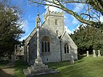
Hannington, Wiltshire

Hannington is a village and civil parish in Wiltshire, England, two miles northwest of Highworth, and now part of the Borough of Swindon. The parish includes the hamlets of Hannington Wick (north of Hannington village) and Swanborough (south, on the border with Highworth parish). The nearest town is Swindon 5.5 miles (9.2 kilometres) and the County town of Wilshire, Trowbridge, is 29.5 miles (47.6 kilometres). The River Thames forms both the northern boundary of the parish and the county boundary with Gloucestershire. John Marius Wilson of the Imperial Gazetteer of England and Wales in 1870 described the village of Hannington as:A village and a parish in Highworth district, Wilts. The village stands 2 miles W by N of Highworth, 2 S of the river Thames at the boundary with Gloucester, and 7 NE of Swindon Junction r. station; is a pretty place, built in the form of the letter Y; and has a post office under Swindon.
Excerpt from the Wikipedia article Hannington, Wiltshire (License: CC BY-SA 3.0, Authors, Images).Hannington, Wiltshire
Queens Road,
Geographical coordinates (GPS) Address Nearby Places Show on map
Geographical coordinates (GPS)
| Latitude | Longitude |
|---|---|
| N 51.638 ° | E -1.749 ° |
Address
Jolly Tar
Queens Road
SN6 7RP
England, United Kingdom
Open on Google Maps


