Fort Kochi
1503 establishments in the Portuguese EmpireNeighbourhoods in KochiTourist attractions in Ernakulam districtTourist attractions in KochiUse Indian English from December 2018

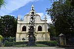
Fort Kochi, Fort Cochin in English, Cochim de Baixo ("Lower Kochi") in Cochin Portuguese creole, is a neighbourhood of Cochin (Kochi) city in Kerala, India. Fort Kochi takes its name from the Fort Manuel of Cochin, the first European fort on Indian soil, controlled by the Portuguese East Indies. This is part of a handful of water-bound islands and islets toward the south-west of the mainland Kochi, and collectively known as Old Cochin or West Cochin. Adjacent to this is the locality of Mattancherry. In 1967, these three municipalities along with a few adjoining areas, were amalgamated to form the Kochi Municipal Corporation.
Excerpt from the Wikipedia article Fort Kochi (License: CC BY-SA 3.0, Authors, Images).Fort Kochi
Bellar Road, Kochi Fort Kochi
Geographical coordinates (GPS) Address Nearby Places Show on map
 Continue reading on Wikipedia
 Geographical coordinates (GPS)
| Latitude | Longitude |
|---|---|
| N 9.968 ° | E 76.244 ° |
Address
Kochi Corporation Zonal Office Fort Kochi
Bellar Road
682001 Kochi, Fort Kochi
Kerala, India
Open on Google Maps