place

Hailwood's Height

Isle of Man stubsRoads in the Isle of ManUse British English from December 2017
A18 at Hailwoods Height (geograph 5722711)

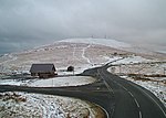
Hailwood's Height, preceded by Hailwood's Rise, is situated between the 31st and 32nd Milestone road-side markers on the Snaefell Mountain Course used for the Isle of Man TT Races on the A18 Snaefell Mountain Road in the parishes of Lezayre and Lonan in the Isle of Man. The uphill section of the Mountain Course from the Bungalow to the highest point of the course at Ordnance Survey spot height 422 metres (1,385 ft) above sea level near Brandywell was named Hailwood's Rise in memory of Mike Hailwood, the former world motorcycle champion who died in 1981. The highest point of the course adjacent to the Brandywell/B10 road junction is named Hailwood's Height.Hailwood's Height and Hailwood's Rise were part of the Highland Course and the Four Inch Course used for the Gordon Bennett Trial and Tourist Trophy automobile car races held in the Isle of Man between 1904 and 1922. Hailwood's Height is now part of the Snaefell Mountain Course used since 1911 for the Isle of Man TT and from 1923 for the Manx Grand Prix Races.

Excerpt from the Wikipedia article Hailwood's Height (License: CC BY-SA 3.0, Authors, Images).

Hailwood's Height
Mountain Road, Lezayre

Geographical coordinates (GPS) Address Nearby Places
placeShow on map

Wikipedia: Hailwood's HeightContinue reading on Wikipedia

Geographical coordinates (GPS)

Latitude Longitude
N 54.243333333333 ° E -4.47 °
placeShow on map

Address

Mountain Road

Mountain Road
Lezayre
Isle of Man
mapOpen on Google Maps

A18 at Hailwoods Height (geograph 5722711)
Share experience

Nearby Places

The Bungalow, Isle of Man

The Bungalow, Isle of Man, one of a handful of better-known vantage points spread around the Snaefell Mountain Course, is situated adjacent to the 31st Milestone roadside marker on the road junction of the primary A18 Mountain Road, the A14 Sulby Glen Road and the road-tramway crossing for the Snaefell Mountain Railway in the parish of Lezayre in the Isle of Man. The Bungalow tramway-crossing was part of the Highland Course and Four Inch Course used for the Gordon Bennett Trial and Tourist Trophy automobile car races held in the Isle of Man between 1904 and 1922. The Bungalow is part of the Snaefell Mountain Course used since 1911 for the Isle of Man TT and from 1923 for the Manx Grand Prix Races. The area is dominated by Snaefell Mountain with an elevation of 621m (2036 feet) above sea level and the nearby summits of Beinn-y-Phott (544m), Mullagh Ouyr (491m), Carraghan (500m), Clagh Ouyr (551m) and North Barrule (565m). The tramway lines of the Snaefell Mountain Railway cross the A18 Mountain Road at the adjacent Bungalow Station. The pedestrian bridge over the road was first erected in time for the 1965 TT races by the Manx Electric Railway Board to allow race spectators access to both sides of the course whilst retaining access to the cafe facilities.The name The Bungalow derives from the former Bungalow Hotel, a Swiss Chalet design, modular-kit wood-built structure with corrugated roof erected by the Isle of Man Tramway and Electrical Power Co, Ltd as part of the Snaefell Mountain Railway. It was rented to Isle of Man Breweries Ltd for £35 per annum in 1900. The Bungalow Hotel was demolished during the winter of 1958 and replaced with a small concrete shelter designed by D.W.Calder. This shelter was in turn demolished in 2002 and replaced by the current Bungalow Station for the Snaefell Railway. The former Ministry of Defence buildings at the Bungalow, a former ROTOR radar station, were previously occupied by Murray's Motorcycle Museum which closed, but has reopened at a new site at Santon in the south-east of the island. The buildings were converted into the Victory Cafe in time for the 2022 Isle of Man TT.