Pico Ruivo
Autonomous Region of Madeira stubsGeography of MadeiraMountains of PortugalOne-thousanders of PortugalPortugal geography stubs ... and 1 more
Tourist attractions in Madeira

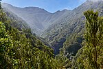
Pico Ruivo is the highest peak on Madeira Island. It can be reached only by foot, usually either from Pico do Areeiro (3rd highest) after a strenuous hike, or from Achada do Teixeira via a shorter, easier trail. There is an additional trail leading west to Encumeada. The hut just below the summit is now open, and there are water tap and toilets available. Pico Ruivo is 1,861 metres (6,106 ft) high and provides panoramic views of the island from coast to coast, but unpredictable weather conditions can make it quite dangerous.
Excerpt from the Wikipedia article Pico Ruivo (License: CC BY-SA 3.0, Authors, Images).Pico Ruivo
Vereda da Encumeada, Santana
Geographical coordinates (GPS) Address Nearby Places Show on map
 Continue reading on Wikipedia
 Geographical coordinates (GPS)
| Latitude | Longitude |
|---|---|
| N 32.758611111111 ° | E -16.942222222222 ° |
Address
Vereda da Encumeada
9030-311 Santana
Portugal
Open on Google Maps