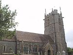
Naish Priory in East Coker, Somerset, England, contains portions of a substantial house dating from the mid 14th century to around 1400. Emery says the building was not a priory as it had been termed by the late 19th-century owner Troyte Chafyn Grove, and there appears no evidence of ownership by a religious house or the residence of a large community of monks on the site. However, there is evidence of a dormitory and communal living dating from the 14th century, and the extant buildings grew on a foundation that had religious obligations by way of chantry to the de Courtenay Earls of Devon from at least 1344. It has been designated as a Grade I listed building, with the attached Priory Cottage and northern boundary railings.Naish Priory and surrounding farm land ("Naish") is a medieval period establishment of Romano–British and Saxon origin, sited directly equidistant between two Roman Villas. During Saxon times it formed part of the estate of Gytha Thorkelsdóttir, which passed to her son Harold II of England as part of his royal manor, and it was a significant journey stop on the important route from Winchester, Salisbury and Shaftesbury into Devon and Cornwall.
The extant 14th century buildings evidence primary links to the important de Courtenay family of the medieval period, Earls of Devon, close blood relatives of the Plantagenet, Lancastrian and Tudor kings, and one of the most important English Renaissance families. They had received rights of the royal Coker Manor via the de Redvers and de Mandeville families who had been given the estates by William II of England after the Norman Conquest that led to their confiscation from Harold Godwinson King of England and his mother. Hutton claimed that the "venerable" Naish was site of the original Coker Manor House of the de Mandeville family.Naish's local and national historic significance is only now, after its Grade 1 listing in 1961 to protect it from encroachment by Yeovil's expansion, beginning to be fully assessed. Naish has been restored since the end of the 19th century and is maintained as a Grade 1 listed unified dwelling.


