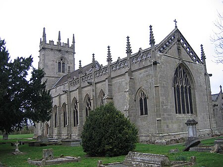
St Mary Magdalene's Church, Battlefield

St Mary Magdalene's Church is in the village of Battlefield, Shropshire, England, dedicated to Jesus' companion Mary Magdalene. It was built on the site of the 1403 Battle of Shrewsbury between Henry IV and Henry "Hotspur" Percy, and was originally intended as a chantry, a place of intercession and commemoration for those killed in the fighting. It is probably built over a mass burial pit. It was originally a collegiate church staffed by a small community of chaplains whose main duty was to perform a daily liturgy for the dead. Roger Ive, the local parish priest, is generally regarded as the founder, although the church received considerable support and endowment from Henry IV. After the dissolution of the college and chantry in 1548, the building was used as the local parish church and it underwent serious decay, punctuated by attempts at rebuilding from the mid-18th century. A restoration in Victorian times was controversial in intention, scope and detail, although many original features remain. Today it is a redundant Anglican church. It is recorded in the National Heritage List for England as a designated Grade II* listed building, and is under the care of the Churches Conservation Trust.
Excerpt from the Wikipedia article St Mary Magdalene's Church, Battlefield (License: CC BY-SA 3.0, Authors, Images).St Mary Magdalene's Church, Battlefield
Battlefield Link Road,
Geographical coordinates (GPS) Address External links Nearby Places Show on map
Geographical coordinates (GPS)
| Latitude | Longitude |
|---|---|
| N 52.7506944 ° | E -2.7235849 ° |
Address
St Mary Magdalene, Battlefield
Battlefield Link Road
SY1 4BF , Battlefield
England, United Kingdom
Open on Google Maps


