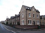
Jericho, Oxford
Areas of OxfordCommons category link is locally definedCulture in OxfordEngvarB from June 2017

Jericho is an historic suburb of the English city of Oxford. It consists of the streets bounded by the Oxford Canal, Worcester College, Walton Street and Walton Well Road. Located outside the old city wall, it was originally a place for travellers to rest if they had reached the city after the gates had closed. The name Jericho may have been adopted to signify this 'remote place' outside the wall. As of February 2021, the population of Jericho and Osney wards was 6,995.
Excerpt from the Wikipedia article Jericho, Oxford (License: CC BY-SA 3.0, Authors, Images).Jericho, Oxford
Cardigan Street, Oxford Jericho
Geographical coordinates (GPS) Address Nearby Places Show on map
Geographical coordinates (GPS)
| Latitude | Longitude |
|---|---|
| N 51.759 ° | E -1.268 ° |
Address
Cardigan Street 75a
OX2 6BQ Oxford, Jericho
England, United Kingdom
Open on Google Maps


