Camuston
Angus geography stubsFormer populated places in ScotlandUse British English from February 2017Villages in Angus, Scotland
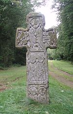
Camuston was a village that once existed in Angus, Scotland until the late 18th/early 19th centuries. No trace of it can be found today, but its former location on land between Panmure House and Camustane Hill can be seen for example in the 1794 map by Ainslie, about half a mile to the East of the Camus Cross Camuston can be found with earlier spelling variations, for example, 'Cambistown' as it is called in documents from 1425–6, and has a Celtic rather than Scandinavian etymology.
Excerpt from the Wikipedia article Camuston (License: CC BY-SA 3.0, Authors).Camuston
Geographical coordinates (GPS) Address Nearby Places Show on map
Geographical coordinates (GPS)
| Latitude | Longitude |
|---|---|
| N 56.531586 ° | E -2.777087 ° |
Address
DD5 3QT
Scotland, United Kingdom
Open on Google Maps


