Silesian Voivodeship

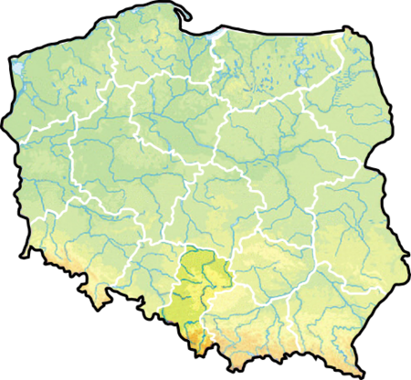
Silesian Voivodeship, or Silesia Province (Polish: województwo śląskie [vɔjɛˈvut͡stfɔ ˈɕlɔ̃skʲɛ]) is a voivodeship, or province, in southern Poland, centered on the historic region known as Upper Silesia (Górny Śląsk), with Katowice serving as its capital. Despite the Silesian Voivodeship's name, most of the historic Silesia region lies outside the present Silesian Voivodeship – divided among Lubusz, Lower Silesian, and Opole Voivodeships. The eastern half of Silesian Voivodeship (and, notably, Częstochowa in the north) was historically part of Lesser Poland. The Voivodeship was created on 1 January 1999 out of the former Katowice, Częstochowa and Bielsko-Biała Voivodeships, pursuant to the Polish local government reforms adopted in 1998. It is the most densely populated voivodeship in Poland. Within the area of 12,300 square kilometres, there are almost 5 million inhabitants. It is also the largest urbanised area in Central and Eastern Europe. In relation to economy, over 13% of Poland's gross domestic product (GDP) is generated here, making the Silesian Voivodeship one of the wealthiest provinces in the country.
Excerpt from the Wikipedia article Silesian Voivodeship (License: CC BY-SA 3.0, Authors, Images).Silesian Voivodeship
Księdza Jana Frenzla, Piekary Śląskie
Geographical coordinates (GPS) Address Nearby Places Show on map
Geographical coordinates (GPS)
| Latitude | Longitude |
|---|---|
| N 50.333333333333 ° | E 19.000277777778 ° |
Address
Księdza Jana Frenzla
Księdza Jana Frenzla
41-948 Piekary Śląskie (Dąbrówka Wielka)
Silesian Voivodeship, Poland
Open on Google Maps


