place

Samnium

Regions of ItalySamnium
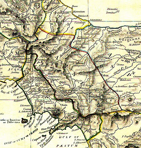
Ancient Samnium (cropped)

Samnium (Italian: Sannio) is a Latin exonym for a region of Southern Italy anciently inhabited by the Samnites. Their own endonyms were Safinim for the country (attested in one inscription and one coin legend) and Safineis for the people. The language of these endonyms and of the population was the Oscan language. However, not all the Samnites spoke Oscan, and not all the Oscan-speakers lived in Samnium. Ancient geographers were unable to relay a precise definition of Samnium's borders. Moreover, the areas it included vary depending on the time period considered. The main configurations are the borders it had during the floruit of the Oscan speakers, from about 600 BC to about 290 BC, when it was finally absorbed by the Roman Republic. The original territory of Samnium should not be confused with the later territory of the same name. Rome's first Emperor, Augustus, divided Italy into 11 regions. Although these entities only served administrative purposes, and were identified with the sole numeral, by scholarly convention the Regio IV has been dubbed "Samnium". Ancient Samnium had actually been divided into three of the Augustan regions.

Excerpt from the Wikipedia article Samnium (License: CC BY-SA 3.0, Authors, Images).

Samnium
Karl-Liebknecht-Straße, Berlin Mitte

Geographical coordinates (GPS) Address Nearby Places
placeShow on map

Wikipedia: SamniumContinue reading on Wikipedia

Geographical coordinates (GPS)

Latitude Longitude
N 41.169444444444 ° E 14.236111111111 °
placeShow on map

Address

Pressehaus

Karl-Liebknecht-Straße
10178 Berlin, Mitte
Berlin, Deutschland
mapOpen on Google Maps

Ancient Samnium (cropped)
Share experience

Nearby Places

Trebula Balliensis
Trebula Balliensis

Trebula or Trebula Balliensis or Trebula Baliensis (Greek: Τρήβουλα), was an ancient city of Campania, Italy, the location of which is occupied by the modern village of Treglia in the comune of Pontelatone. The Monti Trebulani, a small mountain group in the modern province of Caserta, take their name from it. It was situated in the district north of the Vulturnus (modern Volturno), in the mountain tract which extends from near Caiatia (modern Caiazzo) to the Via Latina. Pliny terms the citizens Trebulani cognomine Balinienses, probably to distinguish them from those of the two cities of the same name among the Sabines; but the Campanian town seems to have been the most considerable of the three, and is termed simply Trebula by Ptolemy, as well as by Livy. The first mention of the name occurs in 303 BCE, when we are told that the Trebulani received the Roman franchise at the same time with the Arpinates. There seems no doubt that the Campanian city is here meant: and this is quite certain in regard to the next notice in Livy, where he tells us that the three cities of Compulteria, Trebula, and Saticula, which had revolted to Hannibal, were recovered by Fabius in 215 BCE. The Trebulanus ager is mentioned also by Cicero among the fertile districts of Campania, which Servilius Rullus proposed to distribute among the poorer Roman citizens; and Pliny writes that it was noted for its wines, which had rapidly risen in estimation in his day. The Liber Coloniarum also mentions Trebula among the municipal towns of Campania. It appears to have received a fresh body of settlers under Augustus, but without attaining the rank of a colony.The site of Trebula, which was erroneously fixed by Cluverius and some local writers to the south of the Vulturnus, appears to be correctly identified by local antiquarians with a place called Treglia or Tregghia, at the foot of the Pizzo San Salvatore, about 10 km north of the Vulturnus and 13 km northeast of Capua. There are said to be considerable ancient remains upon the spot, which together with the resemblance of name would seem clearly to establish the position of the ancient city.

Casilinum

Casilinum (Ancient Greek: Κασιλῖνον) was an ancient city of Campania, Italy, situated some 3 miles north-west of the ancient Capua. The position of Casilinum at the junction of the Via Appia and Via Latina, at their crossing of the river Volturnus by a still-existing three-arched bridge, gave the town considerable strategic importance during the Roman Republic.Casilinum was located where the modern city of Capua now stands, while the ancient Capua was located on the site of the modern Santa Maria Capua Vetere. While the original pre-Roman town, doubtless dependent on neighboring Capua, stood entirely on the left (south) bank surrounded on three sides by the river, the Roman city extended to the right bank also. Remains of this later town have been found at some 25 feet below the modern ground-level, the river-bed having since risen considerably.During the Second Punic War, Casilinum was first occupied by Quintus Fabius Maximus Verrucosus in 217 BCE. The town was taken by Hannibal after a gallant defence by troops from Praeneste and Perusia in the winter of 216-215 BCE, but recaptured by Roman forces the following year, thereafter serving the Romans as a base of operations against rebellious Capua.Casilinum eventually lost its independence and became a praefectura. Caesar founded a colony at the town in 59 BCE, which was subsequently renewed by Mark Antony in 44 BCE. The veterans settled within the town took the side of Octavian after Caesar's death.Casilinum appears to have been united with Capua sometime before the reign of Vespasian—the name of the town does not appear in the list of independent communities given by Pliny, who rather (Hist. Nat. iii.70) says that it was fallen into decay (morientis Casilini reliquiae). Only its position at the junction of major roads appears to have redeemed it from insignificance. The period of its final decline or destruction is uncertain but in the 9th century no town was on the spot.