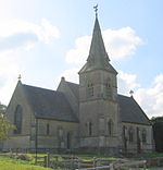
Heywood, Wiltshire

Heywood is a civil parish and small village in the county of Wiltshire in southwestern England. The village is approximately 1.5 miles (2.4 km) north of Westbury and 3.5 miles (5.6 km) south of the county town of Trowbridge. Heywood village, which has approximately 200 inhabitants, lies between the A350 national route and the B3461 road, which links nearby Yarnbrook and the Westbury industrial area. The hamlet of Dursley lies directly to the west of the village on the other side of the railway line. The parish also includes the hamlets of Hawkeridge and Norleaze; in the south are the West Wilts Trading Estate and part of The Ham, close to Westbury. The Biss Brook forms the west and north-west boundary of the parish.
Excerpt from the Wikipedia article Heywood, Wiltshire (License: CC BY-SA 3.0, Authors, Images).Heywood, Wiltshire
Church Road,
Geographical coordinates (GPS) Address Nearby Places Show on map
Geographical coordinates (GPS)
| Latitude | Longitude |
|---|---|
| N 51.281 ° | E -2.184 ° |
Address
Heywood and Hawkeridge Village Hall
Church Road
BA13 4LP , Heywood
England, United Kingdom
Open on Google Maps


