Culford

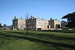
Culford is a village and civil parish about 4 miles (6 km) north of Bury St Edmunds and 62 miles (100 km) north east of London in the West Suffolk district of Suffolk, England. According to the 2011 Census the parish had a population of 578, a decrease from 620 recorded at the 2001 census.A tributary of the River Lark, known as Culford Stream, flows through the centre of the village being fed from Ampton Water in Great Livermere. It continues Westward into West Stow before joining the River Lark at Clough Staunch on the edge of Lackford Lakes.The main village developed along a straight road called "The Street" and there are also some smaller residential areas in Culford, like Benyon gardens, a complex of cul-de-sacs. Most of the houses in central Culford date from the second half of the 1800s and were built as part of the Culford Estate while those at the edges of the village are post-war and later. The centre of the village, along with the Park, and most of West Stow is a conservation area which was established on 4 December 1997. The village also encompasses the hamlets of Culford Heath and Chimney Mills. Culford is home to Culford School, a public school and a member of the Methodist Schools Foundation. The school occupies a former stately home in Culford Park, rebuilt in 1796 for the Cornwallis family.
Excerpt from the Wikipedia article Culford (License: CC BY-SA 3.0, Authors, Images).Culford
B1106, West Suffolk
Geographical coordinates (GPS) Address Nearby Places Show on map
Geographical coordinates (GPS)
| Latitude | Longitude |
|---|---|
| N 52.297 ° | E 0.693 ° |
Address
B1106
IP28 6DS West Suffolk
England, United Kingdom
Open on Google Maps


