Sherwood Forest

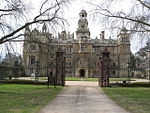
Sherwood Forest is the remnants of an ancient royal forest in Nottinghamshire, England, having an historic association with the legend of Robin Hood. The area has been wooded since the end of the Last Glacial Period (as attested by pollen sampling cores). Today Sherwood Forest National Nature Reserve encompasses 424.75 hectares (1,049.6 acres), surrounding the village of Edwinstowe and the site of Thoresby Hall. Its name is derived from its status as the shire (or sher) wood of Nottinghamshire, which extended into several neighbouring counties (shires), bordered to the west by the River Erewash and the Forest of East Derbyshire. When the Domesday Book was compiled in 1086 the forest covered perhaps a quarter of Nottinghamshire (approximately 19,000 acres or 7,800 hectares) in woodland and heath subject to the forest laws. The forest gives its name to the Parliamentary constituency of Sherwood. Mansfield anciently became the pre-eminent in importance among the towns of the Forest.
Excerpt from the Wikipedia article Sherwood Forest (License: CC BY-SA 3.0, Authors, Images).Sherwood Forest
Broad Drive, Newark and Sherwood
Geographical coordinates (GPS) Address Nearby Places Show on map
Geographical coordinates (GPS)
| Latitude | Longitude |
|---|---|
| N 53.204469444444 ° | E -1.0727611111111 ° |
Address
Broad Drive
NG21 9PF Newark and Sherwood
England, United Kingdom
Open on Google Maps


