place

World's End, Buckinghamshire

Buckinghamshire geography stubsHamlets in BuckinghamshireWendover
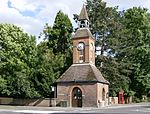
World's End, The End of the World geograph.org.uk 148353

World's End is a hamlet 0.5 miles (0.80 km) north of Wendover, Buckinghamshire. It is part of the civil parish of Wendover which is in Aylesbury Vale district. Today the settlement straddles the B4009. Prior to the construction of the Wendover Bypass World's End was on the A413. The hamlet's name is commonly associated with dwellings or places in remote locations, on the outskirts, or just beyond the limit of a town. Until recently there were two pubs in World's End. The first was called 'The End of the World' which closed in 2006 and in the 19th century was known as 'The Swan Inn'. The second pub was 'The Marquis of Granby' which can be traced back until the 16th century, and has now been renovated and renamed 'The Village Gate'.A large garden centre is located at the north end of the settlement. Along World's End Way, is the old Weston Turville Reservoir. It was constructed to provide water for the Wendover Arm of the Grand Union Canal. It is now a nature reserve and Site of Special Scientific Interest managed by the Berkshire, Buckinghamshire and Oxfordshire Wildlife Trust.

Excerpt from the Wikipedia article World's End, Buckinghamshire (License: CC BY-SA 3.0, Authors, Images).

World's End, Buckinghamshire
Wendover Road,

Geographical coordinates (GPS) Address Nearby Places
placeShow on map

Wikipedia: World's End, BuckinghamshireContinue reading on Wikipedia

Geographical coordinates (GPS)

Latitude Longitude
N 51.775 ° E -0.7557 °
placeShow on map

Address

Wendover Road

Wendover Road
HP22 6BD
England, United Kingdom
mapOpen on Google Maps

World's End, The End of the World geograph.org.uk 148353
Share experience

Nearby Places

Weston Turville Reservoir

Weston Turville Reservoir is a 19 hectare biological Site of Special Scientific Interest south of Weston Turville in Buckinghamshire. It is owned by the Canal & River Trust, and the open water is leased to sailing and fishing clubs while the surrounding land is managed by the Berkshire, Buckinghamshire and Oxfordshire Wildlife Trust. The site is in the Chilterns Area of Outstanding Natural Beauty.The reservoir was built in 1797 to supply water to the Wendover Arm of the Grand Union Canal. Large areas now have a deep silt deposit but in the more open areas, fan-leafed water crowfoot, small pondweed and the European white water lily grow. The southwestern and southern parts have extensive reed beds and this is where water mudwort and orange foxtail are both found, both plants being rare in Buckinghamshire. There is a more varied flora in the southeastern part, with grey clubrush and lesser bulrush. The two chalk streams that flow into the reservoir pass through an area of tall fen and here, and by the side of a small pond, early marsh orchids grow. The trees are mostly grey willow, crack willow, silver birch and other deciduous species.The open water is an important site for 46 species of over-wintering waterfowl, and it is nationally important for shovelers. The areas around the reservoir have tall fen, reed beds and willow carr, declining habitats in Britain. There are over 300 species of beetle, of which six are rare nationally.There is access to the perimeter path around the reservoir from World's End Lane and Halton Lane. The reservoir is home to Aylesbury Sailing Club, which can be accessed on the same path.

Weston Turville
Weston Turville

Weston Turville is a historic village and civil parish in the Vale of Aylesbury in Buckinghamshire, England. The village is at the foot of the Chiltern Hills, 3 miles (4.9 km) from the market town of Wendover and 3.5 miles (5.7 km) from Aylesbury. The village name 'Weston' is Anglo Saxon in origin, and means 'western estate' or western homestead, as 'tun' means an enclosed farm in Angle. In the Domesday Book of 1086, the village is recorded as Westone. The suffix 'Turville' was added later, referring to the lords of the manor in the 13th century, and to differentiate the village from other places called Weston. Between 1236 and 1539, Weston Turville grew to have five areas, or ends – Church End, Brook End, South End, West End and World's End. These five ends still exist, as documented by Hamish Eaton's book "Weston Turville – A History", published in 1997.The 13th century church of St. Mary the Virgin is the parish church for Weston Turville and is a grade I listed building. A church has existed on the land at the end of Church Walk since the 12th century; however, all that remains of the original church is the font and an octagonal shaft built into the south wall of the chancel. The nearest railway station is 1.8 miles (2.9 km) away in the village of Stoke Mandeville on the London to Aylesbury Line, operated by Chiltern Railways. Weekday buses serving Weston Turville run between Aylesbury and RAF Halton, and are operated by Arriva and Redline. Additionally, a service connects to both Aylesbury and Leighton Buzzard on Sundays. Weston Turville has a small bird reserve, which was established by BBONT (Bucks, Beds and Oxford Nature Trust), now BBOWT (Berks, Bucks & Oxon Wildlife Trust). The site had one hide and can be accessed from the main reservoir footpath. Weston Turville was at one time, one of the main places where Aylesbury ducks were bred. In the 18th century selective breeding of white common ducks led to a white domestic duck, generally known as the English White. Since at least the 1690s ducks had been farmed in Aylesbury, and Weston Turville went on to become one of the main areas where these ducks were bred. They were bred and brought up by poor people, and sent to London by the weekly carriers. A notable resident of the village in the 16th century was Dr John Colet. It is after him that the John Colet School in nearby Wendover is named. At one time, the UK TV presenter and Radio DJ Noel Edmonds had a home in Weston Turville. Currently former Arsenal defender Nigel Winterburn and Richard Lapthorne, Chairman of Cable & Wireless Communications, live in the village. Other notable features include: The hamlet of Bye Green is located to the north of the village, on the Brook End (road) leading to Aston Clinton. Weston Turville Golf Club was established in 1973. The 18-hole golf course is situated at the foot of the Chiltern Hills and off the white tees measures 6,008 yards and a par 69 and for the red ladies tees measures 5,369 yards and is a par 70. There are many historic buildings with listed status in Weston Turville and much of the village was designated a conservation area in 1991. Weston Turville Church of England School is a mixed voluntary aided primary school, which takes children from the age of four through to the age of eleven. The school has approximately 210 pupils. Weston Turville Reservoir built in 1797. The Manor House, site of a motte and twin baileys. A local weather station with climatological history of the village. Weston Turville has a well-known audio library, Calibre Audio Library, which opened in 1974. It is located next to the Holiday Inn Hotel.