place

Denby

Civil parishes in DerbyshireGeography of Amber ValleyUse British English from February 2023Villages in Derbyshire
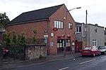
Houses on Church Street, Denby geograph.org.uk 4724101

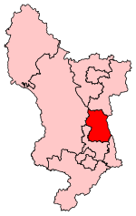
Denby is a village in the English county of Derbyshire that is notable as the birthplace of John Flamsteed, England's first Astronomer Royal, and the location of the Denby Pottery Company. Denby is 3 miles (5 km) east from Belper and 8 miles (13 km) north of Derby. Denby is home to a secondary school which is named after John Flamsteed. The village was once served by Denby railway station on the Midland Railway Ripley Branch. The population at the 2001 Census was 1,827, increasing to 2,190 at the 2011 Census.

Excerpt from the Wikipedia article Denby (License: CC BY-SA 3.0, Authors, Images).

Denby
Derby Road, Amber Valley

Geographical coordinates (GPS) Address Nearby Places
placeShow on map

Wikipedia: DenbyContinue reading on Wikipedia

Geographical coordinates (GPS)

Latitude Longitude
N 53.01974 ° E -1.42531 °
placeShow on map

Address

Derby Road 231
DE5 8NA Amber Valley
England, United Kingdom
mapOpen on Google Maps

Houses on Church Street, Denby geograph.org.uk 4724101
Share experience

Nearby Places

Denby railway station

Denby railway station was a railway station which served the village of Denby in Derbyshire, England. It was opened in 1856 as Smithy Houses by the Midland Railway to on its Ripley branch from Little Eaton Junction (approximately 3 miles north of Derby) to Ripley. Denby itself is a fairly scattered community, but the main part was about a mile away. From November 1858 the timetables began to refer to "Denbey", with the Post Office spelling being adopted in February 1878. Initially there was a low platform on the up-side, but a new higher platform to match those of the other stations was added at some time later on the down-side. An important cargo was coal all from the many mines and opencast workings. An amount of ironstone was also worked but was of low quality. This meant that the local Denby Iron and Coal Company with their four furnaces 45 feet high - later increased to 60 feet - had to import their ironstone from outside the area. They also imported their coal since the local output was of domestic quality rather than being suitable for smelting. The railway provided a siding for this company and also built a facility for processing the slag from the iron production. It so happened in 1901, the Nottingham county surveyor, Edgar Purnell Hooley was visiting the site and noticed some tar that had been spilled and covered with iron foundry slag. A major trouble with highways at that time was the dust raised by increasingly speedy vehicles and various ways had been tried unsuccessfully for binding the road surface. He noticed that it had withstood the passage of traffic and obtained a British patent for producing what he called Tarmac. In 1903 he formed the TarMacadam (Purnell Hooley's Patents) Syndicate Limited.Another customer for the line at this point was the Denby Pottery which had opened in 1809 and had benefitted by the arrival of the railway. It had a siding at Denby Wharf (the terminus of the Little Eaton Gangway) about a third of a mile further north. Each week around three or four vans would be despatched to Chaddesden sidings (near Derby station) where they would be connected to an express to St Pancras and the company's warehouse at the Granary. Added to all this were consignments of milk and agricultural produce from all the farms in the area In the Grouping of all lines (into four main companies) in 1923 the station became part of the London, Midland and Scottish Railway. Passenger services finished in 1930, though the line remained open - primarily for the coal traffic Among the numerous coal workings in the area, the Butterley Company's Denby Hall colliery a mile north of the station was perhaps the most prolific. Investment continued during and after the war, with a washing plant for the colliery which was planned to handle the output of three other collieries, along with the deep Kilburn seam. The facility continued in use until after the station was finally closed in 1965. The track north of the station was lifted completely in 1968 leaving a short length of line in the remains of the station as a head shunt. The station house still survives as a private home, with both platforms greatly overgrown.

Kilburn, Derbyshire
Kilburn, Derbyshire

Kilburn is a village and civil parish in the English county of Derbyshire, known as Kilbourne until around 100 years ago. The population of the civil parish taken at the 2011 Census was 3,618.Forming part of the borough of Amber Valley, Kilburn has few amenities for the people who live there including a local police station, community officer and several parks for young children. There is a Chinese restaurant, Jade Garden. The local fish and chip shop, Kilburn Fish Bar, closed in April 2021. There is a shop in the village, Metro Stores. The village post office is inside of Metro. There are two hair and beauty salons in Kilburn, Amber Hair and Vanity. It was historically served by Kilburn railway station on the Midland Railway Ripley Branch. Kilburn used to have two public houses: The Hunters Arms and the Travellers Rest. Only the Hunters Arm remains open. There is also a working men's club (Kilburn Social Club) adjoined to the football field at the back of Chapel Street. The other prominent features of the village include the War Memorial situated at the top of Bywell Lane, and the Village Hall on Church St, which hosts various leisure activities and is available for residents to hire and use via their Facebook page. Kilburn is served by three schools within the village: Kilburn Nursery (4 - 5), Kilburn Infant School (5 - 7) and Kilburn Junior School (7 - 11). School children then progress to John Flamsteed Community School in Denby until they are 16. There is also a Baptist Chapel as well as a Methodist Chapel, located on Highfield Road and Chapel St, respectively. A number of associations serve the village. The Parish Council is elected from local residents and works toward improving and maintaining the village. The Kilburn Community Association voluntarily maintain and operate the Kilburn Village Hall. A village newsletter, locally circulated, report on the work of these bodies, as well as other institutions such as the local Women's Institute which serves both Kilburn and Denby. There are annual traditions such as a village treasure hunt, a village quiz, the junior school Summer Fair and Christmas Shopping Evening and carol singing which raise funds both for the village and charitable causes in Derbyshire.

Kilburn railway station

Kilburn railway station was a railway station which served the village of Kilburn in Derbyshire, England. It was opened in 1856 by the Midland Railway on its Ripley branch from Little Eaton Junction (approximately 3 miles north of Derby) to Ripley. It was approximately 2 miles from Coxbench and about a mile from Kilburn itself. It did not open until 1 December, three months after the line opened. There was a single platform on the down side, adjacent to the level crossing over the Belper Road. On the other side was the large Station Hotel which still exists but is now a day nursery. Behind this was a brickworks, which is remembered by the name of Brickyard Lane, and nearby a glassworks. However, the main business was from the Kilburn Colliery to the north-east which was served by both north and south facing junctions.In September 1887 the station was burgled. The station master's office was broken into but the money stored there had been removed the previous night. The robber ransacked the office but left without any gains. An 18 year old, John Walker from Chevin View, Belper was later arrested and admitted the offence. He was sent to prison for two months. In the Grouping of all lines (into four main companies) in 1923, the station became part of the London, Midland and Scottish Railway. Passenger services finished in 1930, though the line remained open to Derby for coal traffic until the late twentieth century. Nothing is now left of the station or its tracks, which were demolished in 1965.

Horsley, Derbyshire
Horsley, Derbyshire

Horsley is a small village in the Amber Valley district of Derbyshire, roughly 5 miles north of the City of Derby, England, with a population of 973 at the 2011 Census.The parish church of St Clement and St John, which dates from the 13th century, was rededicated in 1450. It is noted for its fine peal of bells. The main street is Church Street which runs from east to west through the village. Horsley has three main focal points: the village green at the West side of the village, the crossroads of The Dovecote, French Lane and Church Street, and the junction of Church Street, Lady Lea Road and Smalley Mill Road (known locally as "the triangle"). Each of these points boasts a fountain, donated to the village in 1864 by Reverend Sitwell. The fountains were named Sophia, Rosamund and Blanche after the Sitwell family's daughters. The Sitwells of Horlsey, Derbyshire, were related to the Sitwell family of Leamington Hastings, Warwickshire, where they had inherited the lordship of the manor on marrying a Wheler family heiress.The village pub is called the Coach and Horses. Horsley also used to have a second pub called the Ship Inn, but this has been a private house for many years. A recreation ground is situated off French Lane. The rec has a small football pitch and contains the local crown green bowling club. The remains of 12th-century Horsley (Horeston) castle are about a mile away from the village itself. Driving south from the village on Smalley Mill Road you will see Horsley Lodge and Horsley Lodge Golf Club. Opposite the golf club, Springwood Riding Club holds horse shows, on Sundays in the summer.