place

Arnspitze Group

Innsbruck-Land DistrictMountain ranges of BavariaMountain ranges of Tyrol (state)Mountain ranges of the AlpsNature reserves in Austria
Wetterstein
Arnspitzgruppe von S HQ

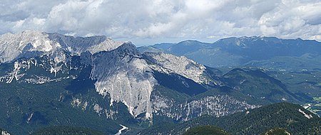
The Arnspitze Group (German: Arnspitzgruppe) is a free-standing mountain chain in Austrian and Germany, in the states of Tyrol and Bavaria, between Seefeld in Tirol and Mittenwald, and between the Leutasch valley in the west and the Isar valley near Scharnitz in the east. In the literature, the Arnspitze Group is classed as part of the Wettersteingebirge. The majority of the group belongs to Tyrol, a northeastern part of the chain lies in Bavaria. The border between Bavaria and Tyrol runs over the summit of the Große Arnspitze.

Excerpt from the Wikipedia article Arnspitze Group (License: CC BY-SA 3.0, Authors, Images).

Arnspitze Group
Achweg,

Geographical coordinates (GPS) Address Nearby Places
placeShow on map

Wikipedia: Arnspitze GroupContinue reading on Wikipedia

Geographical coordinates (GPS)

Latitude Longitude
N 47.397130555556 ° E 11.222541666667 °
placeShow on map

Address

Achweg
6105
Tyrol, Austria
mapOpen on Google Maps

Arnspitzgruppe von S HQ
Share experience

Nearby Places

Erlspitze Group
Erlspitze Group

The Erlspitze Group (German: Erlspitzgruppe), also called the Seefeld Group, is the southwesternmost side range of the Austrian part of the Karwendel mountains in the Alps. It forms a horseshoe-shaped highland around the valley of Eppzirler Tal and is joined in the south to the Nordkette by the Erl Saddle (Erlsattel) near Solsteinhaus. It is bounded in the west by the Seefeld Basin, in the east by the valleys of the Gleirschtal and the Großes Kristental; its forested northern foothills reach as far as Scharnitz. Unlike the four main ranges of the Karwendel, the Erlspitze Group is made of Main Dolomite. Typical of this rock are bizarre weathering forms, like towers, pinnacles and sharply formed arêtes as well as rock arches and caves as a consequence of the rapid erosion of individual rock strata. Its valley bases are Hochzirl, Reith, Seefeld and Scharnitz, all of which are on the Innsbruck-Mittenwald section of the Mittenwald Railway. Two alpine club huts act as bases for tours in the area of the Erlspitze Group: in the west is the Nördlinger Hut and, in the south, is the Solsteinhaus. In the northern part of the Erlspitze Group are two huts open in summer: the Oberbrunnalm and, in the Eppzirler Tal, the Eppzirler Alm. Important peaks (by height) Erlspitze (2,405 m (AA)) Reither Spitze (2,374 m (AA)) Freiungen (2,332 m (AA)) Kuhljochspitze (2,297 m (AA)) Härmelekopf (2,224 m (AA)) Seefelder Spitze (2,221 m (AA)) Fleischbanktürme (2,216 m (AA)) Fleischbankspitze (2,206 m (AA)) Karlspitze (2,174 m (AA)) Seefelder Joch (2,060 m (AA)) Zischgenkopf (1,932 m (AA)) Zäunlkopf (1,746 m (AA))