Greater Bendigo National Park
2002 establishments in AustraliaAustralian protected area stubsBendigoIUCN Category IIImportant Bird Areas of Victoria (state) ... and 5 more
National parks of Victoria (state)Parks of Loddon Mallee (region)Protected areas established in 2002Use Australian English from August 2014Victoria (state) geography stubs

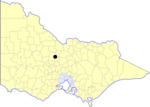
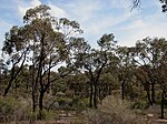
The Greater Bendigo National Park is a national park located in the Loddon Mallee region of Victoria, Australia. The 17,020-hectare (42,100-acre) national park was created in 2002 from the former Whipstick State Park, Kamarooka State Park, One Tree Hill Regional Park, Mandurang State Forest and the Sandhurst State Forest.Much of the park lies within the Bendigo Box-Ironbark Region Important Bird Area, identified as such by BirdLife International because of its importance for swift parrots and other woodland birds.
Excerpt from the Wikipedia article Greater Bendigo National Park (License: CC BY-SA 3.0, Authors, Images).Greater Bendigo National Park
Rifle Range Road, Bendigo
Geographical coordinates (GPS) Address Nearby Places Show on map
Geographical coordinates (GPS)
| Latitude | Longitude |
|---|---|
| N -36.673888888889 ° | E 144.25472222222 ° |
Address
Rifle Range Road
Rifle Range Road
3556 Bendigo (Whipstick)
Victoria, Australia
Open on Google Maps


