place

MacArthur High School (Lawton, Oklahoma)

1969 establishments in OklahomaEducational institutions established in 1969Lawton, OklahomaOklahoma school stubsPublic high schools in Oklahoma
Schools in Comanche County, OklahomaUse mdy dates from October 2011
Ok macarthur 150
Ok macarthur 150

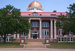
MacArthur High School (MHS) was the third high school built in Lawton, Oklahoma. MacArthur was built and opened for the east Lawton area in 1969. In the late 1960s and early 1970s, the east Lawton area consisted of four additions or neighborhoods which were under development: Carriage Hills, Park Lane, Sullivan Village, and SunGate. MacArthur High School was the first high school in the Lawton, Oklahoma area to provide desegregation busing for the residential subdivision of Ranch Oaks during the 1970s. The Ranch Oaks housing addition was located lateral of the Lawton municipal airport on the east side of Southwest 11th street.

Excerpt from the Wikipedia article MacArthur High School (Lawton, Oklahoma) (License: CC BY-SA 3.0, Authors, Images).

MacArthur High School (Lawton, Oklahoma)
Lawton

Geographical coordinates (GPS) Address Nearby Places
placeShow on map

Wikipedia: MacArthur High School (Lawton, Oklahoma)Continue reading on Wikipedia

Geographical coordinates (GPS)

Latitude Longitude
N 34.609027777778 ° E -98.336958333333 °
placeShow on map

Address


73501 Lawton
Oklahoma, United States
mapOpen on Google Maps

Ok macarthur 150
Ok macarthur 150
Share experience

Nearby Places

Lawton, Oklahoma
Lawton, Oklahoma

Lawton is a city in and the county seat of Comanche County, in the U.S. state of Oklahoma. Located in southwestern Oklahoma, approximately 87 mi (140 km) southwest of Oklahoma City, it is the principal city of the Lawton, Oklahoma, metropolitan statistical area. According to the 2020 census, Lawton's population was 90,381, making it the sixth-largest city in the state, and the largest in Western Oklahoma.Developed on former reservation lands of the Kiowa, Comanche, and Apache Indians, Lawton was founded by European Americans on 6 August 1901. It was named after Major General Henry Ware Lawton, who served in the Civil War, where he earned the Medal of Honor, and was killed in action in the Philippine–American War. Lawton's landscape is typical of the Great Plains, with flat topography and gently rolling hills, while the area north of the city is marked by the Wichita Mountains. The city's proximity to the Fort Sill Military Reservation, formerly the base of the Apache territory before statehood, gave Lawton economic and population stability throughout the 20th century.Although Lawton's economy is still largely dependent on Fort Sill, it has grown to encompass manufacturing, higher education, health care, and retail. The city has a council-manager government; the city council members are elected from single-member districts and the mayor is elected at-large. They hire a professional city manager to direct daily operations. Interstate 44 and three major United States highways serve the city, while Lawton-Fort Sill Regional Airport connects Lawton by air. Recreation can be found at the city's many parks, lakes, museums, and festivals. Notable residents of the city include many musical and literary artists, as well as several professional athletes.