place

Sudbury railway station
1849 establishments in EnglandDfT Category F1 stationsDisused railway stations in SuffolkFormer Great Eastern Railway stationsGreater Anglia franchise railway stations
Pages with no open date in Infobox stationRailway stations in Great Britain closed in 1865Railway stations in Great Britain closed in 1991Railway stations in Great Britain opened in 1849Railway stations in Great Britain opened in 1865Railway stations in Great Britain opened in 1991Railway stations in SuffolkRailway stations opened by British RailSudbury, SuffolkUse British English from November 2017
Sudbury railway station, Suffolk

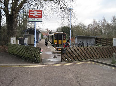
Sudbury railway station is the northern terminus of the Gainsborough Line, a branch off the Great Eastern Main Line in the East of England, serving the town of Sudbury, Suffolk. It is 11 miles 67 chains (19.05 km) down the line from the southern terminus of Marks Tey and 58 miles 32 chains (93.99 km) measured from London Liverpool Street; the preceding station on the branch is Bures. Its three-letter station code is SUY. The platform has an operational length for two-coach trains. The station is currently operated by Greater Anglia, which also operates all trains serving it, as part of the East Anglia franchise. Sudbury is an unstaffed station with one platform as the line is single-track, and with a self-service ticket machine. Volunteers from Sudbury In Bloom man the station, which is annually entered into the Anglia In Bloom station competition; it won the Silver Gilt award in 2006, 2007 and 2008. It also won the Best Station Garden at the 2008 ACoRP Community Rail Awards.

Excerpt from the Wikipedia article Sudbury railway station (License: CC BY-SA 3.0, Authors, Images).

Sudbury railway station
Station Road, Babergh Sudbury

Geographical coordinates (GPS) Address Nearby Places
placeShow on map

Wikipedia: Sudbury railway stationContinue reading on Wikipedia

Geographical coordinates (GPS)

Latitude Longitude
N 52.036 ° E 0.735 °
placeShow on map

Address

Sudbury Station

Station Road
CO10 2RD Babergh, Sudbury
England, United Kingdom
mapOpen on Google Maps

Sudbury railway station, Suffolk
Share experience

Nearby Places

Sudbury, Suffolk
Sudbury, Suffolk

Sudbury (, locally ) is a market town in the south west of Suffolk, England, on the River Stour near the Essex border, 60 miles (97 km) north-east of London. At the 2011 census, it had a population of 13,063. It is the largest town in the Babergh local government district and part of the South Suffolk constituency. Sudbury was an Anglo-Saxon settlement from the end of the 8th century, and its market was established in the early 11th century. Its textile industries prospered in the Late Middle Ages, the wealth of which funded many of its buildings and churches. The town became notable for its art in the 18th century, being the birthplace of Thomas Gainsborough, whose landscapes offered inspiration to John Constable, another Suffolk painter of the surrounding Stour Valley area. The 19th century saw the arrival of the railway with the opening of a station on the historic Stour Valley Railway, and Sudbury railway station forms the current terminus of the Gainsborough Line. In World War II, US Army Air Forces bombers operated from RAF Sudbury. Today, Sudbury retains its status as a market town with a twice-weekly market in the town centre in front of St Peter's Church, which is now a cultural venue for events such as concerts and exhibitions. In sport, the town has a semi-professional football club, A.F.C. Sudbury, which competes at the seventh level of the football pyramid. It is home to the Gainsborough's House museum, celebrating the work of the artist.

Middleton, Essex
Middleton, Essex

Middleton is a village and civil parish in the Braintree District of Essex, England. The village is 1 mile (1.6 km) south from the Ballingdon suburb of the market town of Sudbury. The parish, which is 2 miles (3.2 km) east to west and less than 1 mile north to south, is bordered at the north and east by the county of Suffolk, at the west by the Essex parish of Bulmer and the A131 road, and at the south by the Essex parishes of Little Henny and Great Henny. The River Stour also forms the eastern border. In the north of the parish at Middleton Hall Farm is small light industrial and services park which includes a vehicle sales company and the headquarters of a turkey farm. This was the only farm and only trade listed in 1882 and 1914. By 1894 a carpenter was trading, and in 1902, a baker. The parish contained a mixed National School for 40 children, built in 1875. This had become a Public Elementary School by 1914. Earlier, in 1818, the parish population of 90 had no school. At the end of the 19th-century parish area varied from 868 acres (3.5 km2) to 890 acres (3.6 km2). Parish soil was of clay, loam and gravel, on which was grown wheat, barley, beans and turnips. Between 1881 and 1911, the population dropped from 165 to 133. The Parish Church of All Saints', which dates to the mid-12th century, is a Grade I listed building. Within the church chancel is a 14th-century Purbeck marble figurative floor slab to the memory of a rector of Middleton, died 1349. The parish register dates to 1700. The church seats 150. All Saints' Church was restored in the 19th century, when the bell turret and south porch were rebuilt, a vestry added to the north, and an organ chamber installed. The living at the time was a rectory with a residence and 40 acres (0.2 km2) of glebe – land used for the support of the parish priest and church. In 1882 an oil-on-canvas painting of the Annunciation was reported to be above All Saints' chancel arch, which might have been the work of the 16th-century artist Andrea Schiavone. The rectory house was noted between 1882 and 1902, but not in 1914, as "beautifully situated with a small park in front and contains a splendid collection of oil and water colour paintings by English, Dutch, Flemish, French and Italian masters". At the centre of Middleton Hall Farm is Middleton Hall, built in 1864 but today unlisted; it is part surrounded by a mutilated rectangular moat as a listed monument. A Grade II listed thatched two-storey cottage dating to the 17th century is 250 yards (229 m) southeast from the church on a minor road to Henny Street. South from the church by 60 yards (55 m), and with access from Rectory Road is Queens Beeches, a Grade II listed early 19th-century grey brick house with attached stables and carriage house.