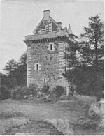
Bedrule

Bedrule (Scottish Gaelic: Ruail Bheathaig) is a hamlet and civil parish in the historic county of Roxburghshire in the Scottish Borders area of Scotland. The hamlet lies on the east side of the Rule Water, which gave the village its name, about 4 miles west of Jedburgh. It lies south of the A698 between Hawick and Jedburgh. Other local place-names based on the river include Hallrule, Abbotrule, Ruletownhead and Spittal-on-Rule. Larger settlements include Bonchester Bridge and Denholm, as well as Hawick and Jedburgh. The Rule Water forms the western boundary of the parish, separating it from Hobkirk and Cavers. The north-west boundary is on or near the Teviot, beyond which lies Ancrum. The parish is bounded on the east and south by Jedburgh parish. Bedrule lies on the path of the Borders Abbeys Way, a long-distance trail. The civil parish has a population of 185 (in 2011).
Excerpt from the Wikipedia article Bedrule (License: CC BY-SA 3.0, Authors, Images).Bedrule
Bedrule Bridge,
Geographical coordinates (GPS) Address Nearby Places Show on map
Geographical coordinates (GPS)
| Latitude | Longitude |
|---|---|
| N 55.454 ° | E -2.634 ° |
Address
Bedrule Bridge
TD9 8TE
Scotland, United Kingdom
Open on Google Maps


