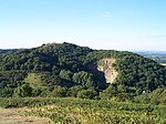
Midsummer Hill
Former populated places in HerefordshireHerefordshire building and structure stubsHill forts in HerefordshireHills of WorcestershireMalvern Hills ... and 1 more
Marilyns of England

Midsummer Hill is situated in the range of Malvern Hills that runs approximately 13 kilometres (8 mi) north-south along the Herefordshire-Worcestershire border. It lies to the south of Herefordshire Beacon with views to Eastnor Castle. It has an elevation of 284 metres (932 ft). To the north is Swinyard Hill. It is the site of an Iron Age hill fort which spans Midsummer Hill and Hollybush Hill. The hillfort is protected as a Scheduled Ancient Monument and is owned by Natural England. It can be accessed via a footpath which leads south from the car park at British Camp on the A449 or a footpath which heads north from the car park in Hollybush on the A438.
Excerpt from the Wikipedia article Midsummer Hill (License: CC BY-SA 3.0, Authors, Images).Midsummer Hill
A438, Malvern Hills
Geographical coordinates (GPS) Address Website Nearby Places Show on map
Geographical coordinates (GPS)
| Latitude | Longitude |
|---|---|
| N 52.0353 ° | E -2.3505 ° |
Address
Midsummer Hill Camp
A438
HR8 1ET Malvern Hills
England, United Kingdom
Open on Google Maps


