Kowloon Walled City

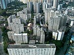
Kowloon Walled City was an ungoverned and densely populated de jure Chinese enclave within the boundaries of Kowloon City, British Hong Kong. Originally a Chinese military fort, the walled city became an enclave after the New Territories were leased to the United Kingdom by China in 1898. Its population increased dramatically following the Japanese occupation of Hong Kong during World War II. By 1990, the walled city contained 50,000 residents within its 2.6-hectare (6.4-acre) borders. From the 1950s to the 1970s, it was controlled by local triads and had high rates of prostitution, gambling, and drug abuse.In January 1987, the Hong Kong government announced plans to demolish the walled city. After an arduous eviction process, and the transfer of de jure sovereignty of the enclave from China to Britain, demolition began in March 1993 and was completed in April 1994. Kowloon Walled City Park opened in December 1995 and occupies the area of the former walled city. Some historical artefacts from the walled city, including its yamen building and remnants of its southern gate, have been preserved there.
Excerpt from the Wikipedia article Kowloon Walled City (License: CC BY-SA 3.0, Authors, Images).Kowloon Walled City
Tung Tau Tsuen Road, Kowloon Kowloon City (Kowloon City District)
Geographical coordinates (GPS) Address Nearby Places Show on map
 Continue reading on Wikipedia
 Geographical coordinates (GPS)
| Latitude | Longitude |
|---|---|
| N 22.332222222222 ° | E 114.19027777778 ° |
Address
前九龍寨城衙門 Former Yamen Building of Kowloon Walled City
Tung Tau Tsuen Road
Kowloon, Kowloon City (Kowloon City District)
Hong Kong, China
Open on Google Maps