place

Redding Center Historic District
Colonial Revival architecture in ConnecticutConnecticut Registered Historic Place stubsGreek Revival architecture in ConnecticutHistoric districts in Fairfield County, ConnecticutHistoric districts on the National Register of Historic Places in Connecticut
Italianate architecture in ConnecticutNRHP infobox with nocatNational Register of Historic Places in Fairfield County, ConnecticutRedding, ConnecticutUse mdy dates from May 2023
Redding Center
Redding Center

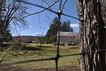
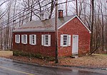
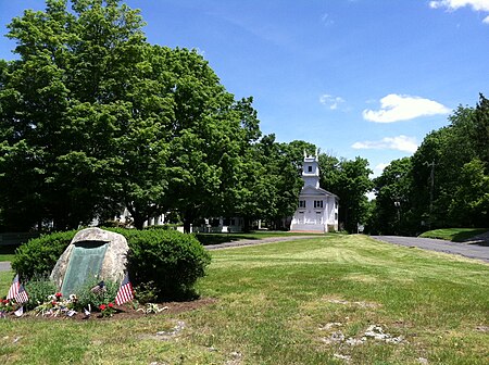
The Redding Center Historic District is a 55-acre (22 ha) located in Redding, Connecticut, encompassing its historic village center. It includes the town's current and former town halls, a church, a cemetery, private homes and barns. The district was added to the National Register of Historic Places on October 1, 1992.The district includes 46 buildings with a mix of architectural styles, including Colonial Revival, Greek Revival, and Italianate. They form the most historically significant collection of properties in the community.Fronting a central green is the First Church of Christ, a Congregational church built in 1837 in the Greek Revival style that was the first religious organization established in Redding, obtaining permission in 1729 from Fairfield church leaders to establish a separate parish. Also facing the green is Redding's old town hall, built in 1834 and still used today for some town functions like meetings. Redding's current town hall, police station, fire station, and the Read Cemetery, which has grave markers dating from 1786 to 1860, are also in the district.

Excerpt from the Wikipedia article Redding Center Historic District (License: CC BY-SA 3.0, Authors, Images).

Redding Center Historic District
Hill Road,

Geographical coordinates (GPS) Address Nearby Places
placeShow on map

Wikipedia: Redding Center Historic DistrictContinue reading on Wikipedia

Geographical coordinates (GPS)

Latitude Longitude
N 41.303888888889 ° E -73.381944444444 °
placeShow on map

Address

Hill Road 96
06896
Connecticut, United States
mapOpen on Google Maps

Redding Center
Redding Center
Share experience

Nearby Places

Joel Barlow High School

Joel Barlow High School is a public high school serving students in ninth through twelfth grades in Redding, Fairfield County, Connecticut, United States. The school serves Easton and Redding students. The school is the sole institution in the Region 9 School District of Connecticut, made up of the towns of Redding and Easton, which each have their own public school systems for education up to the eighth grade. The Board of Education acts as its own Board of Finance, and although it reports to the boards of finance in both towns, they have no control over the school budget. Each year a referendum is held on the school budget and must be passed by a majority of voters in the two towns.As of the 2015-16 school year, the school had an enrollment of 1,008 students and 71.4 classroom teachers (on an FTE basis), for a student–teacher ratio of 14.1:1. There were 33 students (3.3% of enrollment) eligible for free lunch and 12 (1.2% of students) eligible for reduced-cost lunch.For the purpose of comparison with the achievement levels of similar schools, the state Department of Education classifies schools and communities in "District Reference Groups", defined as "districts whose students' families are similar in education, income, occupation and need, and that have roughly similar enrollment". Its total minority enrollment is 13%, 6% of which are Hispanic. Joel Barlow High School (Region 9) is one of eight school districts in District Reference Group A (others are Darien, Easton, New Canaan, Redding, Ridgefield, Westport, and Wilton). It is ranked #15 within the state of Connecticut and #696 in National Rankings of Public High Schools.

Saugatuck Reservoir
Saugatuck Reservoir

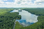
The Saugatuck Reservoir is a reservoir in Fairfield County, Connecticut, United States, that straddles the border between the towns of Redding, Weston, and Easton. Its completion is marked by the creation of the Samuel P. Senior dam of the Saugatuck River in January 1942, and provides water to several of the nearby towns. The reservoir is surrounded by the Centennial Watershed State Forest and a small section of the Trout Brook Valley State Park Reserve on the southeast end of the reservoir. The Saugatuck Reservoir utilizes an uncontrolled spillway adjacent to the Samuel P. Senior dam that effectively limits the maximum water level. There is also a concrete levee positioned on the southeastern side of the reservoir that prevents water from flooding Trout Brook Valley. Bridgeport Hydraulic Company Holdings (now owned by Aquarion) flooded the Saugatuck River Valley after 1938, removing the villages of Hull and Valley Forge to create the Saugatuck Reservoir.Aquarion Water Co., owner of the reservoir and dam, allows tailrace fishing in one area at the Weston end of the reservoir, where it has constructed a handicapped-access area. However, anglers must obtain a permit from Aquarion before fishing in the Saugatuck.The Saugatuck is the largest of the eight reservoirs that make up Aquarion’s greater Bridgeport water system. It holds about 12 billion US gallons (45,000,000 m3) of water.The following fish species may be found within the Saugatuck Reservoir: American eel Bluegill (Sunfish) Brook trout Brown trout Bullhead catfish Chain pickerel Crappie Largemouth bass Pumpkinseed (Sunfish) Rainbow trout Rock bass Smallmouth bass Walleye White perch Yellow perch