Rancho Potrero de los Cerritos
1844 establishments in Alta CaliforniaCalifornia ranchosFremont, CaliforniaRanchos of Alameda County, California
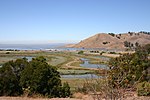
Rancho Potrero de los Cerritos was a 10,610-acre (42.9 km2) Mexican land grant in present day Alameda County, California given in 1844 by Governor Manuel Micheltorena to Augustin Alviso and Tomás Pacheco. The name means "pasture of the little hills" and included the Coyote Hills. The three square league grant, part of former Mission San José lands, encompassed present day Fremont, Alvarado, Centerville and Irvington.
Excerpt from the Wikipedia article Rancho Potrero de los Cerritos (License: CC BY-SA 3.0, Authors).Rancho Potrero de los Cerritos
Farmhouse Street, Fremont
Geographical coordinates (GPS) Address Nearby Places Show on map
Geographical coordinates (GPS)
| Latitude | Longitude |
|---|---|
| N 37.57 ° | E -122.06 ° |
Address
Farmhouse Street 33843
94555 Fremont
California, United States
Open on Google Maps


