place

Wetterwandeck

Garmisch-Partenkirchen (district)Mountains of BavariaMountains of Tyrol (state)Mountains of the AlpsTwo-thousanders of Austria
Two-thousanders of GermanyWetterstein
Zugspitze Schneefernerkpf1

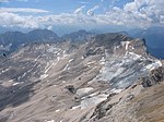
The Wetterwandeck is a summit, 2,698 m high, in the Wetterstein mountains on the Austro-German border. It is located south of Germany's highest peak, the Zugspitze, above the Southern Schneeferner in the ridge which borders the Zugspitzplatt to the south. The first verifiable ascent of the Wetterwandeck was in 1874 by Hermann von Barth.A drag lift in the ski region on the Zugspitzplatt below the Wetterwandeck was named after the mountain. There is also a piste at the southern foot of the mountain known as the Ehrwalder Almbahnen.

Excerpt from the Wikipedia article Wetterwandeck (License: CC BY-SA 3.0, Authors, Images).

Wetterwandeck
Gletscherrundweg,

Geographical coordinates (GPS) Address Nearby Places
placeShow on map

Wikipedia: WetterwandeckContinue reading on Wikipedia

Geographical coordinates (GPS)

Latitude Longitude
N 47.398055555556 ° E 10.976944444444 °
placeShow on map

Address

Wetterwandeckbahn

Gletscherrundweg
82475
Bavaria, Germany
mapOpen on Google Maps

Zugspitze Schneefernerkpf1
Share experience

Nearby Places

Zugspitze
Zugspitze

The Zugspitze (German pronunciation: [ˈtsuːkʃpɪtsə]), at 2,962 m (9,718 ft) above sea level, is the highest peak of the Wetterstein Mountains as well as the highest mountain in Germany. It lies south of the town of Garmisch-Partenkirchen, and the Austria–Germany border runs over its western summit. South of the mountain is the Zugspitzplatt, a high karst plateau with numerous caves. On the flanks of the Zugspitze are three glaciers, including the two largest in Germany: the Northern Schneeferner with an area of 30.7 hectares and the Höllentalferner with an area of 24.7 hectares. The third is the Southern Schneeferner which covers 8.4 hectares.The Zugspitze was first climbed on 27 August 1820 by Josef Naus, his survey assistant, Maier, and mountain guide, Johann Georg Tauschl. Today there are three normal routes to the summit: one from the Höllental valley to the northeast; another out of the Reintal valley to the southeast; and the third from the west over the Austrian Cirque (Österreichische Schneekar). One of the best known ridge routes in the Eastern Alps runs along the knife-edged Jubilee Ridge (Jubiläumsgrat) to the summit, linking the Zugspitze, the Hochblassen and the Alpspitze. For mountaineers there is plenty of nearby accommodation. On the western summit of the Zugspitze itself is the Münchner Haus and on the western slopes is the Wiener-Neustädter Hut. Three cable cars run to the top of the Zugspitze. The first, the Tyrolean Zugspitze Cable Car, was built in 1926 by the German company Adolf Bleichert & Co and terminated on an arête below the summit at 2,805 m.a.s.l, the so-called Kammstation, before the terminus was moved to the actual summit at 2,951 m.a.s.l. in 1991. A rack railway, the Bavarian Zugspitze Railway, runs inside the northern flank of the mountain and ends on the Zugspitzplatt, from where a second cable car takes passengers to the top. The rack railway and the Eibsee Cable Car, the third cableway, transport an average of 500,000 people to the summit each year. In winter, nine ski lifts cover the ski area on the Zugspitzplatt. The weather station, opened in 1900, and the research station in the Schneefernerhaus are mainly used to conduct climate research.