place

Shrewsbury railway station

1848 establishments in EnglandBuildings and structures in ShrewsburyDfT Category C1 stationsFormer Shrewsbury and Hereford Railway stationsFormer Shrewsbury and Wellington Joint Railway stations
Grade II listed buildings in ShropshireGrade II listed railway stationsPages with no open date in Infobox stationRailway stations in Great Britain opened in 1848Railway stations in ShropshireRailway stations served by Avanti West CoastRailway stations served by Transport for Wales RailRailway stations served by West Midlands TrainsThomas Mainwaring Penson railway stationsUse British English from March 2017
Shrewsbury station
Shrewsbury station

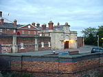
Shrewsbury railway station is in Shrewsbury, Shropshire, England. Built in 1848, it was designated a grade II listed building in 1969. The station is 43 miles (69 km) north west of Birmingham New Street. Many services starting at or passing through the station are bound for Wales, and it is a key hub for its operator, Transport for Wales. Services are also provided by Avanti West Coast and West Midlands Railway.

Excerpt from the Wikipedia article Shrewsbury railway station (License: CC BY-SA 3.0, Authors, Images).

Shrewsbury railway station
Beacall's Lane,

Geographical coordinates (GPS) Address Nearby Places
placeShow on map

Wikipedia: Shrewsbury railway stationContinue reading on Wikipedia

Geographical coordinates (GPS)

Latitude Longitude
N 52.712 ° E -2.75 °
placeShow on map

Address

3

Beacall's Lane
SY1 2HU , Castlefields
England, United Kingdom
mapOpen on Google Maps

Shrewsbury station
Shrewsbury station
Share experience

Nearby Places

Bagley Brook

The Bagley Brook is a small watercourse that flows into the River Severn at Shrewsbury in Shropshire, England. Its course has been severely altered by urban development in the area, such that the brook is now little known or seen. However its name is used for an official area name - Bagley - which is an electoral division of the county council and a ward of the town council. The brook follows to some extent the old course of the River Severn which was cut off from the course of the Severn at the last glaciation period. When the River Severn floods in a severe way, such as in November 2000, the area around the Bagley Brook also floods (about 20 hectares (49 acres)).In present times, the watercourse starts roughly where the Ellesmere Road (the A528) crosses the old course of the Severn, and runs through the marshy area at first in a southeasterly direction, then a southerly direction. This area has been designated as an SSSI under the name Old River Bed, Shrewsbury.It then runs through a cutting to the east of the Shrewsbury–Crewe railway line, eventually passing between a new housing development ("Ellesmere Grange") and a coal yard. It then enters a long underground culvert. The water discharges into the Severn at Chester Street, where the Gateway public building is, between Coton Hill and the town centre. Historically there was a bridge to carry the road over the brook, but the watercourse now flows through a culvert from the north of the Shrewsbury–Chester railway line straight into the river and cannot now be seen at Chester Street.