place

Worcester Park

Areas of LondonDistrict centres of LondonDistricts of the London Borough of SuttonUse British English from September 2015
Christ Church with St. Philip, Cheam Common Road (A2043) geograph.org.uk 32661

Worcester Park is a suburban town in South West London, England. It lies in the London boroughs of Sutton and Kingston, and partly in the Surrey borough of Epsom and Ewell. The area is 10.1 miles (16.3 km) southwest of Charing Cross. The suburb's population was 16,031 at the time of the 2001 census. The suburb comprises the Worcester Park ward, an electoral area of the London Borough of Sutton with a population in 2011 of 11,655, as well as the Cuddington ward, an electoral area of Epsom and Ewell, which had a population of 5,791 at the time of the 2001 census.The Worcester Park post town, which is coterminous with the KT4 postcode district, covers all of the suburb and also extends into Old Malden. The Beverley Brook runs through Worcester Park, alongside Green Lane and past Green Lane Primary School and Cheam Common Junior School for the special needs, traversing up to Cuddington Recreation Ground. Green Lane appears in the Domesday Book. The Huntsmans Hall (now The Brook) was situated on what was the far boundary of a hunting ground for Henry VIII.

Excerpt from the Wikipedia article Worcester Park (License: CC BY-SA 3.0, Authors, Images).

Worcester Park
Knolls Close, London Worcester Park (London Borough of Sutton)

Geographical coordinates (GPS) Address Nearby Places
placeShow on map

Wikipedia: Worcester ParkContinue reading on Wikipedia

Geographical coordinates (GPS)

Latitude Longitude
N 51.3752 ° E -0.239 °
placeShow on map

Address

Knolls Close

Knolls Close
KT4 8UR London, Worcester Park (London Borough of Sutton)
England, United Kingdom
mapOpen on Google Maps

Christ Church with St. Philip, Cheam Common Road (A2043) geograph.org.uk 32661
Share experience

Nearby Places

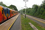
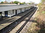
Worcester Park railway station

Worcester Park railway station serves the Worcester Park area in south-west London, England. It is 10 miles 53 chains (17.2 km) down the line from London Waterloo. It opened in 1859 when the London and South Western Railway completed the Epsom branch. It was originally known as "Old Malden" and was renamed "Worcester Park" in 1862. Following substantial local housing development, the station was refurbished in the 1930s. The station is in the Royal Borough of Kingston upon Thames, just to the west of the boundary with the London Borough of Sutton. The station is managed by South Western Railway, which also operates all trains serving it, and it is located in Travelcard Zone 4. The station has a small concession stand selling newspapers, magazines, coffee and pastries. There is a taxi office on the station estate; bus stops served by various Transport for London routes; a 24-hour, 90-space car park; cycle parking; a waiting room and toilets. The car park is largely sited on the area formerly used as a goods yard. The station has no automated barriers; however, Oyster Pre-Pay has been made available by National Rail at the station. Disabled access used to be poor: the London bound platform was accessible, but access to the southbound platform was only via the pedestrian bridge or a long set of steps. However, in June 2014 a new passenger bridge was opened (coinciding with the removal of the old footbridge). The new bridge is equipped with lifts to permit disabled access between platforms.In December 2007 there was a landslide on the line near the station which caused major disruptions and cancellations to all services passing through the station for one week.