Rocca Bernauda
Alpine three-thousandersFrance geography stubsFrance–Italy borderInternational mountains of EuropeItaly geography stubs ... and 3 more
Mountains of Hautes-AlpesMountains of PiedmontMountains of the Alps

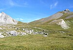
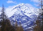
Rocca Bernauda (French: Roche Bernaude) is a mountain of the Alps of 3,222 metres (10,571 ft). It has been the westernmost point of Italy since the cession of Valle Stretta (Vallée Étroite) at the Paris Peace Treaties of 1947. It is in the Cottian Alps close to Bardonecchia between the Susa Valley, Durance and Maurienne Valley With the Arc River. Geologically, it has quartzites and gneiss, especially at the peak.
Excerpt from the Wikipedia article Rocca Bernauda (License: CC BY-SA 3.0, Authors, Images).Rocca Bernauda
Geographical coordinates (GPS) Address Nearby Places Show on map
Geographical coordinates (GPS)
| Latitude | Longitude |
|---|---|
| N 45.103055555556 ° | E 6.6266666666667 ° |
Address
05100
Provence-Alpes-Côte d'Azur, France
Open on Google Maps


