Moffat Hills
Geology of ScotlandMountain ranges of ScotlandMountains and hills of Dumfries and GallowayMountains and hills of the Scottish BordersMountains and hills of the Southern Uplands ... and 3 more
Protected areas of Dumfries and GallowaySites of Special Scientific Interest in Annandale and EskdaleUse British English from November 2013

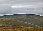
The Moffat Hills are a range of hills in the Southern Uplands of Scotland. They form a roughly triangular shape with a west facing side, a north facing side, and a south-east facing side. It is 17 kilometres from east to west across this triangle and some 16 kilometres north to south. The highest point is White Coomb at 821 m (2694 ft). The town of Moffat lies just south of the Moffat hills and along with Tweedsmuir, at the northern extremity, is the only centre of population around these hills. In some older maps, the northern part of the Moffat Hills is called the Tweedsmuir Hills, but can also be known by the title Manor Hills.
Excerpt from the Wikipedia article Moffat Hills (License: CC BY-SA 3.0, Authors, Images).Moffat Hills
Geographical coordinates (GPS) Address Nearby Places Show on map
Geographical coordinates (GPS)
| Latitude | Longitude |
|---|---|
| N 55.423 ° | E -3.384 ° |
Address
Scottish Borders
Scotland, United Kingdom
Open on Google Maps


