Zikrin
Arab villages depopulated during the 1948 Arab–Israeli WarDistrict of HebronPages with non-numeric formatnum argumentsTalmud places

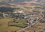
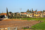
Zikrin (Arabic: ذكرين), pronounced Dhikrin, was a Palestinian Arab village in the Hebron Subdistrict, depopulated in the 1948 Palestine War. The site is located about 6 kilometres (3.7 mi) northwest of Beit Gubrin and sits at a mean elevation of 212 metres (696 ft) above sea-level, its access somewhat impeded by hedges of buckthorn and cactus. The entire site is dotted with grottoes and caves, and razed structures.
Excerpt from the Wikipedia article Zikrin (License: CC BY-SA 3.0, Authors, Images).Zikrin
Yoav Regional Council
Geographical coordinates (GPS) Address Nearby Places Show on map
Geographical coordinates (GPS)
| Latitude | Longitude |
|---|---|
| N 31.663333333333 ° | E 34.860555555556 ° |
Address
מועצה אזורית יואב
Yoav Regional Council
South District, Israel
Open on Google Maps


