place

Karjamaa, Tallinn

Commons category link is locally definedSubdistricts of TallinnTallinn geography stubs
Karjamaa asumi kaart

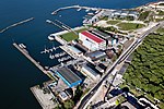
Karjamaa (Estonian for "Pasture", literally "Grazing Land") is a subdistrict (Estonian: asum) in the district of Põhja-Tallinn, Tallinn, the capital of Estonia. It's located northwest of Kalamaja and east of Sitsi, main part is between Kopli, Tööstuse and Erika streets. Karjamaa also includes the Hundipea area and the Mine Harbour (Miinisadam) by the Tallinn Bay. Karjamaa has a population of 5,314 (As of 1 January 2014).The name "Karjamaa" meaning pasture, was carried over to the neighbourhood because the area was mostly used as a pasture before the 19th century. The first known settlement in the Hundipea area is mentioned in 1374 as Zudenpeyke (Susipea). Karjamaa is also known as Sitsimägi (Chintz Hill). In 1728 a large stone building, which housed the navy hospital for a short time, was built in the area. The settlement was also influenced by the establishment of Kopli cemetery (in Kopli), a new road passed through Karjamaa. The biggest changes in the area took place in the end of the 19th century when the Baltic Cotton Factory with its dwellings were built nearby (the neighbourhood now known as Sitsi). Directly before the World War I the Mine Harbour and war factory "Arsenal" were built in Karjamaa. The Arsenal submachine gun is probably their most famous product.

Excerpt from the Wikipedia article Karjamaa, Tallinn (License: CC BY-SA 3.0, Authors, Images).

Karjamaa, Tallinn
Karjamaa, Tallinn Põhja-Tallinna linnaosa

Geographical coordinates (GPS) Address Nearby Places
placeShow on map

Wikipedia: Karjamaa, TallinnContinue reading on Wikipedia

Geographical coordinates (GPS)

Latitude Longitude
N 59.452557 ° E 24.711449 °
placeShow on map

Address

Karjamaa 7
10416 Tallinn, Põhja-Tallinna linnaosa
Estonia
mapOpen on Google Maps

Karjamaa asumi kaart
Share experience

Nearby Places

Kalamaja
Kalamaja

Kalamaja (Estonian for Fish House; German: Fischermay) is a subdistrict of the district of Põhja-Tallinn (Northern Tallinn) in Tallinn, the capital of Estonia. It is located just northwest of the historical town centre, on the coast of the Tallinn Bay. Kalamaja has a population of 9,820 (As of 1 January 2015).Kalamaja is one of the best preserved wooden architecture areas in Tallinn and Estonia. The quiet neighbourhood has long been known for its colourful hodgepodge of old fashioned, working class houses. Throughout most of Tallinn's history Kalamaja served as the city's main fishing harbour. Starting from the 14th century the area was traditionally dominated by fishermen, fishmongers and boat wrights. A new era began in 1870, when Tallinn was connected to Saint Petersburg by railroad. The Tallinn railway station (Balti jaam), was built between Kalamaja and the city centre. Suddenly enormous factories started to sprout up in this part of town, and they brought with them an influx of thousands of new workers. The wooden houses, which have become Kalamaja's architectural legacy, were built to accommodate these workers.Most of the Kalamaja's main sightseeings are located on the coast of Kalamaja. In 2011 a former railway embankment was converted into a walking trail called "Culture Kilometre" (Kultuurikilomeeter). The walk-way starts next to the Tallinn harbour passes the Creative Hub (Kultuurikatel), continues past the historic Patarei Prison and Sea Fortress, the region's biggest sea centre Seaplane Harbour (Lennusadam) and ends at the end of Kalamaja park on Tööstuse street. In 2015, the former Kultuurikilomeeter was converted into a street, which quickly became one of the defining streets of the neighbourhood.