place

Punch Bowl Falls

Columbia River GorgeMount Hood National ForestOregon geography stubsPunch bowl waterfallsWaterfalls of Hood River County, Oregon
Waterfalls of Oregon
Punch Bowl Falls
Punch Bowl Falls

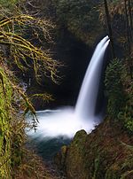
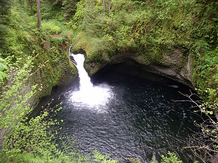
Punch Bowl Falls is a waterfall on Eagle Creek in the Columbia River Gorge National Scenic Area, Oregon, United States. Eagle Creek drains into the Columbia River, with its outlet on the Columbia River Gorge in Multnomah County. The falls is 35 feet (11 m) tall and 10 feet (3.0 m) wide. Eagle Creek cuts through a narrow channel and shoots powerfully into a large bowl that resembles a punchbowl. This waterfall was responsible for the waterfall classification type of punchbowl. These falls are not to be confused with another set of falls with the same name, found in Jasper National Park, Alberta, Canada near Miette Hot Springs. In 2017, the cliff on the left side of the creek collapsed between Punch Bowl and Lower Punch Bowl Falls. Debris from the landslide changed the stream's flow between waterfalls. A little up the river, there is a dilapidated wooden staircase leading to a concrete fish ladder.

Excerpt from the Wikipedia article Punch Bowl Falls (License: CC BY-SA 3.0, Authors, Images).

Punch Bowl Falls
Eagle Creek Trail #440,

Geographical coordinates (GPS) Address Nearby Places
placeShow on map

Wikipedia: Punch Bowl FallsContinue reading on Wikipedia

Geographical coordinates (GPS)

Latitude Longitude
N 45.62183 ° E -121.89325 °
placeShow on map

Address

Eagle Creek Trail #440 (PCT - Eagle Creek Alternate)

Eagle Creek Trail #440

Oregon, United States
mapOpen on Google Maps

Punch Bowl Falls
Punch Bowl Falls
Share experience

Nearby Places

Sheridan State Scenic Corridor

Sheridan State Scenic Corridor is a state park in the Columbia River Gorge, west of Cascade Locks, Oregon. The 11-acre (4.5 ha) property, containing an old-growth forest, is located on the south side of Interstate 84 at approximately milepoint 42.5, and was not accessible by motor vehicle since I-84 was built in 1960. However, with the opening of the Eagle Creek-Cascade Locks segment of the Historic Columbia River Highway State Trail in 1998, it has become easily accessible by foot or bicycle. The park is on a triangular lot, surrounded by I-84 and the Mount Hood National Forest. The park was acquired in 1923 from the Oregon-Washington Railroad and Navigation Company by the Parks Division of the State Highway Department, which named it for Philip H. Sheridan. It served as a wayside on US 30 - the Historic Columbia River Highway - until 1960, when the new I-84 freeway replaced the old road, cutting off access except through the national forest. As part of the restoration of the old highway, the Federal Highway Administration rebuilt the abandoned Eagle Creek-Cascade Locks for non-motorized traffic in the 1990s, to be managed by the State Parks and Recreation Department. An interpretive sign was installed at the site in 2007.Just to the east of the park, within the national forest the trail passes under I-84 in a 150-foot (50 m) long precast concrete rock-faced tunnel (45.6501°N 121.9107°W / 45.6501; -121.9107). The $500,000 structure was built as part of the restoration project, and was required to connect the park to another intact piece of road, located north of I-84 at the west Cascade Locks interchange.

Bridge of the Gods (modern structure)

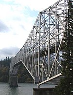
The Bridge of the Gods is a steel truss cantilever bridge that spans the Columbia River between Cascade Locks, Oregon, and Washington state near North Bonneville. It is approximately 40 miles (64 km) east of Portland, Oregon, and 4 miles (6.4 km) upriver from Bonneville Dam. It is a toll bridge operated by the Port of Cascade Locks. The bridge was completed by the Wauna Toll Bridge Company and opened in 1926 at a length of 1,127 feet (344 m). The higher river levels resulting from the construction of the Bonneville Dam required the bridge to be further elevated by 44 feet (13 m) in 1938 and extended to its current length of 1,858 feet (566 m). The Columbia River Bridge Company of Spokane, Washington, acquired ownership of the bridge in 1953 for $735,000 (equivalent to $8.04 million today). The Port of Cascade Locks purchased the bridge with $950,000 (or $9.3 million today) in revenue bonds, issued on November 1, 1961. The Port of Cascade Locks Commission owns and operates the bridge still today. The bridge is named after the historic geologic feature also known as Bridge of the Gods. The Pacific Crest Trail crosses the Columbia River on the Bridge of the Gods. The lowest elevation of the trail is about a mile north from the bridge at 110 feet (34 m).Onlookers in September 1927 saw Charles Lindbergh fly the Spirit of St. Louis from Portland low over the new bridge and then, in a bit of barnstorming, make a 180 degree turn and fly back under the bridge, continuing to the Portland Airport, then on Swan Island.For many years, the bridge toll was $1 per crossing; In 2016, it was raised to $2 due to the increased traffic after the release of the 2014 film Wild. The toll was increased to $3 in July, 2022.