Pioneer Valley

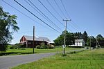
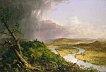
The Pioneer Valley is the colloquial and promotional name for the portion of the Connecticut River Valley that is in Massachusetts in the United States. It is generally taken to comprise the three counties of Hampden, Hampshire, and Franklin. The lower Pioneer Valley corresponds to the Springfield, Massachusetts metropolitan area, the region's urban center, and the seat of Hampden County. The upper Pioneer Valley region includes the smaller cities of Northampton and Greenfield, the county seats of Hampshire and Franklin counties, respectively. Historically the northern part of the Valley was an agricultural region, known for growing Connecticut shade tobacco and other specialty crops like Hadley asparagus; however, since the late 19th century its economy has become increasingly a knowledge economy, due to the prominence of the Five Colleges in Hampshire County. Similarly the Springfield-Chicopee-Holyoke economies transformed from volume producers of goods such as paper and armaments, into a combination of specialized manufacturing and distribution services for Boston and New York. Many of the cities and towns include areas of forests, and Springfield itself, which in the early twentieth century was nicknamed "The City in a Forest," features nature within its city limits and over 12% parkland. The Pioneer Valley is known for its scenery and as a vacation destination. The Holyoke Range, Mount Tom Range, and numerous rolling hills, bluffs, and meadows feature extravagant homes from the Gilded Age, many of which surround New England's longest and largest river, the Connecticut River, which flows through the region.The name Pioneer Valley originates in the 20th century with travel writers using it in the 1920s and 1930s to designate the region. In 1939 the Pioneer Valley Association was formed to promote the region using that name.
Excerpt from the Wikipedia article Pioneer Valley (License: CC BY-SA 3.0, Authors, Images).Pioneer Valley
Hockanum Road,
Geographical coordinates (GPS) Address Nearby Places Show on map
Geographical coordinates (GPS)
| Latitude | Longitude |
|---|---|
| N 42.3 ° | E -72.6 ° |
Address
Hockanum Road 130
01035
Massachusetts, United States
Open on Google Maps


