Inzersdorf (Vienna)
1120s establishments in EuropeHouse of KinskyKatastralgemeinde of ViennaLiesing

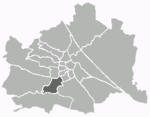
Inzersdorf (German pronunciation: [ˈɪnt͡sɐsˌdɔʁf] (listen); before 1893 Inzersdorf am Wienerberge, 1893 - 1938 Inzersdorf bei Wien; Central Bavarian: Inzasduaf) was before 1938 an independent municipality, and is now a part of the 23rd Viennese district Liesing. Today, the cadastral commune Inzersdorf has got an area of 854.06 hectares (3.2975 sq mi) and is so on the biggest part of the district. But in the 19th century, independent Inzersdorf had also got place in the today 10th Viennese district, and bordered on the villages Vösendorf, Leopoldsdorf, Ober‑ and Unterlaa, and (in the west) on Erlaa.
Excerpt from the Wikipedia article Inzersdorf (Vienna) (License: CC BY-SA 3.0, Authors, Images).Inzersdorf (Vienna)
Drascheparksteg, Vienna KG Inzersdorf (Liesing)
Geographical coordinates (GPS) Address Nearby Places Show on map
Geographical coordinates (GPS)
| Latitude | Longitude |
|---|---|
| N 48.1525 ° | E 16.340555555556 ° |
Address
Drascheparksteg
Drascheparksteg
1230 Vienna, KG Inzersdorf (Liesing)
Austria
Open on Google Maps


