Oderbruch

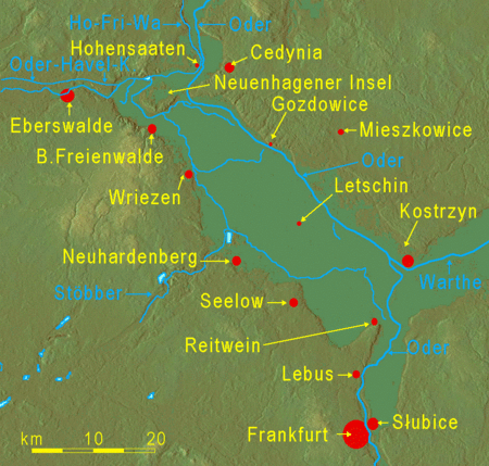
The Oderbruch (Polish: Kotlina Freienwaldzka) is a landscape located at the Oder river in eastern Germany on the Polish border, with a small part also in Poland. It extends from the towns Oderberg and Bad Freienwalde in the north to Lebus in the south, in the county of Märkisch-Oderland in the state of Brandenburg. The Oderbruch is about 60 km long and its width varies from 12 to 20 km for a total area of some 920 km2. It is a slightly inclined plane descending from 14 m in the southeast to just one meter above sea level in the northwest. The German name Oderbruch comes from Middle High German brouch meaning a marshy ground, swamp or moor (bruch is related to the English term brook), while the Polish name refers to Bad Freienwalde. The Prussian king Frederick the Great initiated the drainage of the Oderbruch in order to bring this large tract of marshland under cultivation. Since that time the land west of the river has been river polder, whereas the 17% of the Oderbruch which is now in Poland has retained its original wetland character. The region experienced two months of heavy fighting which devastated the area at the close of World War II when Marshal Georgy Zhukov led the 1st Belorussian Front through the Oderbruch on the way to Berlin.
Excerpt from the Wikipedia article Oderbruch (License: CC BY-SA 3.0, Authors, Images).Oderbruch
L 34, Barnim-Oderbruch
Geographical coordinates (GPS) Address Nearby Places Show on map
Geographical coordinates (GPS)
| Latitude | Longitude |
|---|---|
| N 52.7 ° | E 14.25 ° |
Address
L 34
15324 Barnim-Oderbruch (Alttrebbin)
Brandenburg, Germany
Open on Google Maps


