Tuxedo, Winnipeg

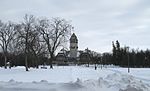
Tuxedo is a residential suburb of Winnipeg, Manitoba. Prior to 1972, the community was incorporated as the Town of Tuxedo. Today, it is the wealthiest area of Winnipeg, with the highest property values. It is located about 7 kilometres (4.5 miles) southwest of downtown Winnipeg and borders the Assiniboine River and Assiniboine Park on the north, Assiniboine Forest on the west, and Edgeland Boulevard to the east. It is also bordered by Kenaston Boulevard and Taylor Avenue, the latter street being named after Frank Trafford Taylor, who was a prominent resident of Tuxedo. It is part of the city ward of Charleswood-Tuxedo-Westwood, as well as belonging to the provincial electoral district of Tuxedo, and the federal electoral district of Winnipeg South Centre.
Excerpt from the Wikipedia article Tuxedo, Winnipeg (License: CC BY-SA 3.0, Authors, Images).Tuxedo, Winnipeg
Hosmer Boulevard, Winnipeg
Geographical coordinates (GPS) Address Nearby Places Show on map
 Continue reading on Wikipedia
 Geographical coordinates (GPS)
| Latitude | Longitude |
|---|---|
| N 49.861944444444 ° | E -97.221944444444 ° |
Address
Hosmer Boulevard
Hosmer Boulevard
R3P 0N3 Winnipeg
Manitoba, Canada
Open on Google Maps