place

Chesterwood

Hamlets in NorthumberlandNorthumberland geography stubsUse British English from August 2019
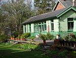
Cottages at Chesterwood. geograph.org.uk 2021139

Chesterwood is a hamlet in Northumberland, in England. It is situated a short distance to the north-west of Haydon Bridge on the South Tyne, west of Hexham. It includes a number of "Bastle Houses" from the 17th Century, originally built to protect against raids by the Border Reivers. Unusually some of these Bastles are terraced. Just a couple of miles south of the Historic Hadrians Wall (Roman Wall) it lies in the Parish of Haydon and once had a Tower as the boundary of the property of the Barony of Langley. Langley Castle is located 3 miles south on the opposite side of the South Tyne Valley. There is an historical account of a murder in Chesterwood as burglars attempted to open the front door of the Bastle now known as "The Golf House" (so named as it was the club-house of a 9-hole golf course at the beginning of the 20th century). Frank Stokoe had his daughter slide the door bolt shut while he exited the house and crept around to the front door where he shot the would-be intruder dead.

Excerpt from the Wikipedia article Chesterwood (License: CC BY-SA 3.0, Authors, Images).

Geographical coordinates (GPS)

Latitude Longitude
N 54.9806 ° E -2.267 °
placeShow on map

Address


NE47 6HP , Haydon
England, United Kingdom
mapOpen on Google Maps

Cottages at Chesterwood. geograph.org.uk 2021139
Share experience

Nearby Places

Hadrian's Wall
Hadrian's Wall

Hadrian's Wall (Latin: Vallum Hadriani, also known as the Roman Wall, Picts' Wall, or Vallum Aelium in Latin) is a former defensive fortification of the Roman province of Britannia, begun in AD 122 in the reign of the Emperor Hadrian. Running from Wallsend on the River Tyne in the east to Bowness-on-Solway in the west of what is now northern England, it was a stone wall with large ditches in front and behind, stretching across the whole width of the island. Soldiers were garrisoned along the line of the wall in large forts, smaller milecastles, and intervening turrets. In addition to the wall's defensive military role, its gates may have been customs posts. Hadrian's Wall Path generally runs close along the wall. Almost all the standing masonry of the wall was removed in early modern times and used for local roads and farmhouses. None of it stands to its original height, but modern work has exposed much of the footings, and some segments display a few courses of modern masonry reconstruction. Many of the excavated forts on or near the wall are open to the public, and various nearby museums present its history. The largest Roman archaeological feature in Britain, it runs a total of 73 miles (117.5 kilometres). Regarded as a British cultural icon, Hadrian's Wall is one of Britain's major ancient tourist attractions. It was designated a UNESCO World Heritage Site in 1987. The turf-built Antonine Wall of AD 142 in what is now central Scotland, which briefly superseded Hadrian's Wall before being abandoned, was declared a World Heritage Site in 2008. Hadrian's Wall marked the boundary between Roman Britannia and unconquered Caledonia to the north. The wall lies entirely within England and has never formed the Anglo-Scottish border, though it is sometimes loosely or colloquially described as such.