Pokegama River (St. Louis River tributary)
Minnesota river stubsNorthern Wisconsin geography stubsRivers of Douglas County, WisconsinRivers of MinnesotaRivers of Wisconsin ... and 1 more
Wisconsin river stubs
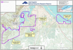
The Pokegama River is a 26.3-mile-long (42.3 km) river in Wisconsin and Minnesota in the United States. It is a tributary of the Saint Louis River, joining it in the western part of the city of Superior, Wisconsin.
Excerpt from the Wikipedia article Pokegama River (St. Louis River tributary) (License: CC BY-SA 3.0, Authors).Pokegama River (St. Louis River tributary)
Billings Drive,
Geographical coordinates (GPS) Address Nearby Places Show on map
 Continue reading on Wikipedia
 Geographical coordinates (GPS)
| Latitude | Longitude |
|---|---|
| N 46.681388888889 ° | E -92.154166666667 ° |
Address
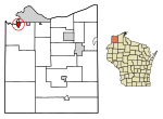
Billings Drive
Billings Drive
54880 , South Superior
Wisconsin, United States
Open on Google Maps