place

Harris River

Rivers of Hampton, VirginiaRivers of VirginiaVirginia river stubs

The Harris River is a 2.5-mile-long (4.0 km) tidal river within the city of Hampton in the U.S. state of Virginia. It is a southerly arm of the Back River, an inlet of Chesapeake Bay.

Excerpt from the Wikipedia article Harris River (License: CC BY-SA 3.0, Authors).

Harris River
Harris Creek Road, Hampton Fox Hill

Geographical coordinates (GPS) Address Nearby Places
placeShow on map

Wikipedia: Harris RiverContinue reading on Wikipedia

Geographical coordinates (GPS)

Latitude Longitude
N 37.0932 ° E -76.30911 °
placeShow on map

Address

Marina Cove Boat Basin

Harris Creek Road
23669 Hampton, Fox Hill
Virginia, United States
mapOpen on Google Maps

Share experience

Nearby Places

Eight-Foot High Speed Tunnel

The Eight-Foot High Speed Tunnel, also known as Eight-Foot Transonic Tunnel, was a wind tunnel located in Building 641 of NASA's Langley Research Center in Hampton, Virginia. It was a National Historic Landmark.The tunnel was completed in 1936 at a cost of $36,266,000. Because of its high speed and Bernoulli's principle, the pressure in the test section is much lower than that in the rest of the tunnel. This required a structure that could withstand an inward force due to the pressure difference. Instead of steel construction, it was built from reinforced concrete with walls up to 1 ft (0.3 m) thick. This resulted in an "igloo-like" structure at the test section. The wind tunnel was designed as a single-return tunnel capable of moving air at speeds up to a Mach number up to 0.75. It was powered by an 8,000 hp (6,000 kW) electric motor. It was repowered to 16,000 hp (12,000 kW) to give Mach number 1 capability in 1945. In 1947, the speed was increased to a Mach number of 1.2 with the installation of a contoured nozzle. In 1950, a slotted-throat test section was installed, and it was repowered to 25,000 hp (19,000 kW). Because it was the first continuous-flow high-speed tunnel, this tunnel was a landmark in wind tunnel design. This meant it could operate almost indefinitely to produce a high-speed airstream approaching the speed of sound. And it was large enough to accommodate large-scale models and even full-scale aircraft sections. In 1950, the tunnel was the first in the world to be modified to incorporate a slotted throat design. This revolutionary design gave researchers their first accurate data on airframe performance in the transonic range. The tunnel was deactivated in 1956, when a new 8-foot (2.4 m) tunnel was built near it. The wind tunnel was used for critical tests that validated the area rule for the design of supersonic aircraft. This said that the fuselage of the aircraft should narrow at the wings and expand at their trailing edges. This resulted in "wasp-waisted" aircraft. The tunnel was taken out of service in 1956. It was declared a National Historic Landmark in 1985. In 2011, Building 641, which housed the tunnel, was demolished. The landmark designation was withdrawn in 2014, and it was removed from the National Register of Historic Places.There are additional photographs of the wind tunnel in the Historic American Engineering Record collection.

Full-Scale Wind Tunnel

The Full-Scale Tunnel (abbreviated FST, also known as the 30-by 60-Foot Tunnel) was a wind tunnel at NASA's Langley Research Center. It was a National Historic Landmark. In 1929, National Advisory Committee for Aeronautics began construction of the world's first full-scale wind tunnel. The design team was led by Smith J. DeFrance. The tunnel was completed in 1931 (dedicated 27 May) at a cost just under $900,000. It was a double-return tunnel capable of moving air at speeds up to 118 miles/hour (190 km/h) through its circuit. It had a 30 ft by 60 ft (9.1 m x 18.3 m) open throat, which is capable of testing aircraft with spans of 40 ft (12.2 m). The wind tunnel was a double-return, atmospheric pressure tunnel with two fans powered by 4,000 hp electric motors. The Vought O3U-1 biplane observation airplane was the first complete airplane tested in the tunnel. After that, it was used to test virtually every high-performance aircraft used by the United States in World War II. For much of the war, when it was operational 24 hours a day, seven days a week, the full-scale tunnel was the only tunnel in the free world large enough to perform these tests. After the war, many types of aircraft were tested in the tunnel including the Harrier jump jet fighter, the F-16, the American supersonic transport, the Space Shuttle and Lunar Landing Test Vehicle. During the 1950s and 1960s, the tunnel was modified and upgraded several times. The principal improvement was adding the ability to test free-flying scale models in the test throat. The wind tunnel was in use through the 2000s, testing procedures such as free-flight and high angle of attack.It was declared a National Historic Landmark in 1985. However, despite this designation and the efforts of some aviation historians, demolition of the tunnel began in 2010. It was documented before its demolition, with the fan blades being salvaged for display. In 2014 its landmark designation was withdrawn and it was removed from the National Register of Historic Places.

Back River (Virginia)

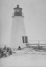
The Back River is an estuarine inlet of the Chesapeake Bay between the independent cities of Hampton and Poquoson in the Hampton Roads area of southeastern Virginia. Formed by the confluence of the Northwest and Southwest Branches, and at just over two miles (3.2 km) long, the Back River is a breeding ground for many of the Bay's prized sport fish and the well known blue crab. The river was once part of an important fishing area that provided the local canneries with the famous Chesapeake seafood that was, and still is in demand throughout the country. Although now used primarily for recreation and as a wildlife refuge, the river remains a great place to spend an afternoon with a fishing rod or a few crab traps. Factory Point, a peninsula that protects the river from the Chesapeake Bay sits at the mouth of the river adjoining the bay. The Southwest Branch begins as Newmarket Creek, a marshy, tidal creek which flows from its headwaters in Newport News into Hampton where it widens greatly and empties into the river. The Northwest Branch also begins in Newport News as Brick Kiln Creek and is dammed along with the Hampton city and York County border to form Big Bethel Reservoir. It flows from the reservoir into Poquoson, where it becomes the Northwest Branch. The Back River Lightstation, or Grandview Light, formerly stood on a windswept beach at the mouth of the river. Constructed in 1829 by Winslow Lewis, with a cost of $4,250, the thirty-foot brick tower displayed its light until 1915, when it was automated and the keepers removed. In 1936, the station was decommissioned and left open to the elements and vandals. Hurricane Flossy in 1956 delivered the final blow and toppled the tower. All that can be seen today is a pile of debris just off the beach.

Bay Shore Beach

Bay Shore Beach was a beach that existed adjacent to Buckroe Beach in Hampton, Virginia in the 20th century. It was founded in 1898 by several African-American businessmen. The beach was one of the most popular resort and vacation destinations in the Mid-Atlantic region for African-Americans. In addition to standard beach activities, hotels, and restaurants, Bay Shore also had an amusement park. The beach was in its prime of popularity from 1898 until 1933 when a Hurricane devastated the coast. Both "sides" of the beach, (Bay Shore & Buckroe) were respectively rebuilt, however, Bay Shore may not have been built back to its former heights, although it continued to remain popular.Frank D. Banks, an administrator at Hampton Normal and Agricultural Institute, led the effort to develop beachfront property on the Chesapeake Bay. Head bookkeeper at Hampton Institute, Banks helped organize People's Savings and Loan in 1888. He also helped establish the Hampton Supply Company. Banks formed the Bay Shore Hotel Company with a group of local leaders that included John Mallory Phillips and Robert Moton. Phillips operated a seafood business on the Hampton River. Moton also was an administrator at Hampton Institute.After the hurricane, Charles H. Williams led the effort to redevelop the property. Another key figure in the rebuilding effort was Lawrence Barbour, a Hampton graduate who was an executive at People's Building and Loan Association. Williams served as president of the New Bay Shore Hotel Corporation and managed the property for many years.Bay Shore beach ceased to exist by the early 1970s. Buckroe Beach, its white counterpart, continues to exist although its golden era ended with the upstart of Virginia Beach located in the city of Virginia Beach, Virginia. Currently, the property that was once Bay Shore Beach has been privately developed to various degrees by developers.