Fulde (Böhme)

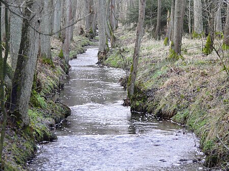
The Fulde is a river of Lower Saxony, Germany. It belongs to the Weser river system. It is about 11 kilometres (6.8 mi) long and flows entirely within the territory of the borough of Walsrode (Heidekreis district. It rises in a valley between two parallel end moraines formed in the Saalian Ice Age. By far the largest source drains the Grundloses Moor ("bottomless moor"), 4 kilometres (2.5 mi) north of Fulde and emerges from the Kleiner See ("Little Lake") there. Another source appears 2.5 kilometres (1.6 mi) northwest of the village of Fulde, which gave the stream its name. From there the Fulde runs through, at times, picturesque scenery between steep, grass-covered, clay banks and fish ponds south of the Walsrode town forest of Eckernworth, where the Rischmannshof Heath Museum is located, crosses the centre of the town through the Fulde Park with its town hall and joins the River Böhme south of the Walsrode Abbey lake.
Excerpt from the Wikipedia article Fulde (Böhme) (License: CC BY-SA 3.0, Authors, Images).Fulde (Böhme)
Kienmoorweg,
Geographical coordinates (GPS) Address Nearby Places Show on map
Geographical coordinates (GPS)
| Latitude | Longitude |
|---|---|
| N 52.90445 ° | E 9.5552 ° |
Address
Moorerlebnispfad Grundloses Moor
Kienmoorweg
29664
Lower Saxony, Germany
Open on Google Maps


