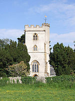
Curry Mallet
Civil parishes in SomersetVillages in South Somerset

Curry Mallet (anciently "Cory Mallett") is a village and parish in Somerset, England. It is on the Fivehead River (also known as the River Ile), 7 miles (11.3 km) east of Taunton in the South Somerset district. The village has a population of 306.
Excerpt from the Wikipedia article Curry Mallet (License: CC BY-SA 3.0, Authors, Images).Curry Mallet
Redland Lane,
Geographical coordinates (GPS) Address Nearby Places Show on map
Geographical coordinates (GPS)
| Latitude | Longitude |
|---|---|
| N 50.9889 ° | E -2.963 ° |
Address
Redland Lane
Redland Lane
TA3 6ST , Curry Mallet
England, United Kingdom
Open on Google Maps


