place

Boylan Heights

Boylan family residencesColonial Revival architecture in North CarolinaHistoric districts on the National Register of Historic Places in North CarolinaNRHP infobox with nocatNational Register of Historic Places in Raleigh, North Carolina
Neighborhoods in Raleigh, North CarolinaQueen Anne architecture in North CarolinaRaleigh, North Carolina Registered Historic Place stubsUse mdy dates from August 2023
BoylanHeightsHome
BoylanHeightsHome

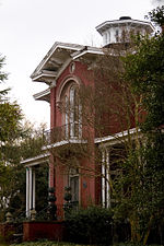
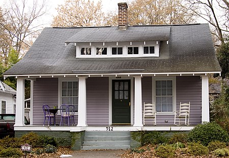
Boylan Heights is a historic neighborhood in Raleigh, North Carolina. It was added to the National Register of Historic Places as a historic district on July 29, 1985. It is also one of six local Historic Overlay Districts in Raleigh. Boylan Heights has been explored in the book Everything Sings: Maps for a Narrative Atlas by resident and critical cartographer Denis Wood, which maps the neighborhood in unusual ways. In the introduction to the book, Wood writes that these maps explore "other ways of thinking about [Boylan Heights] . . . as some sort of community, or as a marriage of community and place, or as those people in that place, their relationships, and their ways in the world . . . a life process." Maps include the location of jack-o'-lanterns on porches, radio waves permeating the air, the light from street lamps, and other attributes of Boylan Heights that cannot be mapped in a traditional way.The national historic district encompasses 252 contributing buildings and was developed between about 1907 and 1935. It includes notable examples of Queen Anne, Colonial Revival, and Bungalow / American Craftsman style architecture.Its name was used for the 1987 album Boylan Heights by The Connells. There is a restaurant named after the district in The Corner neighborhood of Charlottesville, Virginia.

Excerpt from the Wikipedia article Boylan Heights (License: CC BY-SA 3.0, Authors, Images).

Boylan Heights
Cutler Street, Raleigh Warehouse District

Geographical coordinates (GPS) Address Nearby Places
placeShow on map

Wikipedia: Boylan HeightsContinue reading on Wikipedia

Geographical coordinates (GPS)

Latitude Longitude
N 35.773888888889 ° E -78.651944444444 °
placeShow on map

Address

Cutler Street 568
27603 Raleigh, Warehouse District
North Carolina, United States
mapOpen on Google Maps

BoylanHeightsHome
BoylanHeightsHome
Share experience

Nearby Places

Joel Lane House
Joel Lane House

The Joel Lane House, also known as Wakefield, was built in 1769 and is now a restored historic home and museum in Raleigh, North Carolina. It is the oldest dwelling in Wake County and contains collections of 18th century artifacts and period furnishings. The museum grounds include a detached middle-class home built circa 1790, a formal city garden, and a period herb garden. The house is named after Joel Lane, the "Father of Raleigh" and "Father of Wake County."In the late 1760s, Lane settled at Wake Cross Roads located in colonial Johnston County. Lane and his house played a key role in North Carolina's transition from colony to state and in the establishment of Raleigh as the state capital. Joel Lane's plantation manor stood on a small hill overlooking the future site of Raleigh. Lane owned thousands of acres, which enabled him to be influential in politics. Lane was a member of the colonial General Assembly, and successfully lobbied to create Wake County in 1770, which was, at the time, a sparsely-settled wilderness. The county was named "Wake" in honor of Margaret Wake, wife of colonial Governor William Tryon. In 1771, Wake County's first county court is believed to have convened at his home. Lane was appointed a member of the court, a position he held until his death. During the Revolutionary War, Wake Cross Roads was the site of important government meetings, both formal and informal. In 1776, Lane hosted the colony Council of Safety; the following year, he obtained a license for a small inn. From May to June 1781, Lane's property was the setting for a session of the state General Assembly. Lane served in the state Senate in 11 of the 14 sessions from 1782 to 1794. He was also a delegate to the 1789 convention in Halifax that ratified the United States Constitution. Lane was directly involved in the decision to locate the permanent capital of the state in Wake County. In 1792, the legislature authorized the purchase of 1,000 acres (4 km2) of his land upon which to establish the city of "Raleigh" as the new center of state government. The community's western boundary was drawn just east of Lane's house, and a street of the city was named in his honor. After Lane's death in 1795, Lane's house served several owners before being purchased by businessman William Boylan in 1818. The house, along with Montfort Hall, remained in the Boylan family until 1909. During this time, the city of Raleigh absorbed the house into its expanding boundaries. Lane's former plantation became the site of new streets, homes and businesses. In 1911, the house was moved a short distance. In 1927, Lane's house was purchased by the National Society of Colonial Dames of America in the State of North Carolina to ensure its preservation. The organization continues to operate this Raleigh Historic Landmark as a house museum.In 2019, to celebrate the house's 250th anniversary, a restoration team removed 26 layers of paint in order to repair the damaged wood underneath. The house was then repainted to match its original color of garnet red.