place

Winnall, Hampshire

City of WinchesterFormer civil parishes in Hampshire
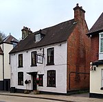
The Golden Lion, Winnall, Winchester geograph.org.uk 685112

Winnall is a northern suburb of Winchester, Hampshire, England, on the east bank of the River Itchen. It is the location of the Winnall Moors nature reserve on the flood-plain of the Itchen and the University of Southampton's Erasmus Park hall of residence. Winnall is also the location of St Swithun's School, Winnal Primary school and Winchester's main industrial estate, occupying land between the A34 and the former Didcot, Newbury and Southampton Railway, by junction 9 of the M3. The name is presumed to derive from Wilighealh, a Saxon name probably relating to willows, mentioned in the Domesday Book as part of nearby Chilcomb. It appears in its modern spelling on a 1575 map by Saxton. Winnall was an ancient parish (incorporating that of St Giles by the late 13th century), but was later absorbed by Winchester, and is not a modern civil parish.

Excerpt from the Wikipedia article Winnall, Hampshire (License: CC BY-SA 3.0, Authors, Images).

Winnall, Hampshire
Winnall Manor Road, Winchester Winnall

Geographical coordinates (GPS) Address Nearby Places
placeShow on map

Wikipedia: Winnall, HampshireContinue reading on Wikipedia

Geographical coordinates (GPS)

Latitude Longitude
N 51.065335 ° E -1.29707 °
placeShow on map

Address

Winnall Manor Road

Winnall Manor Road
SO23 0NN Winchester, Winnall
England, United Kingdom
mapOpen on Google Maps

The Golden Lion, Winnall, Winchester geograph.org.uk 685112
Share experience

Nearby Places

Winchester city walls

Winchester city walls are a series of defensive walls in central Winchester, originally built during the Roman settlement of southern Britain, in what was then the settlement of Venta Belgarum. The area surrounding Winchester had been populated throughout the Iron Age, with Britonnic settlements existing at Oram's Arbour, St Catherine's Hill, and Worthy Down; Venta Belgarum took its name from the Belgae tribes of the area. Earthwork defences were constructed around the end of the second century, being rebuilt in stone during the latter part of the third century..Under Saxon rule, Alfred the Great rebuilt Winchester and its defences as part of the burh system developed to protect against Norse incursions. Winchester was later chosen as the location of one of the first Norman castles in England, with Winchester Castle being built alongside the walls in 1067. As well as the royal castle in the West of the city, Wolvesey Castle, the palace of the Bishop of Winchester, was built in the East of the City alongside the River Itchen; during the Civil War known as The Anarchy, the forces of Queen Matilda, on behalf of King Stephen, besieged the forces of Empress Matilda, destroying much of the old city including the urban defences, in an event known as the Rout of Winchester.Whilst Winchester's city walls went through periods of decline, by the 14th century, the city had 6 gates, the West Gate, South Gate, King's Gate, East Gate, North Gate and Durn Gate. In the English Civil War, the city was seized on behalf of the King by royalist Sir William Ogle, before being captured by Parliamentary forces led by Sir William Waller; the city was subsequently recovered by the Royalist forces before being recaptured by Parliament after the Battle of Cheriton, after which much of the castle was demolished, apart from the Great Hall.During the 18th century, much of the walls and gates were demolished due to the relatively low height of the gates and their hazards to pedestrians, with the Eastgate demolished in 1768, and the Southgate demolished from 1771. The Northgate also collapsed in 1756. Today only the Kingsgate and Westgate survive, with other portions of the wall existing around the gates and Winchester Castle, as well as alongside the Itchen by the remains of Wolvesey Castle, with other sections having been demolished or repurposed. Sections of the wall remain as listed and protected areas.

Hampshire
Hampshire

Hampshire (, ; abbreviated to Hants.) is a ceremonial county in South East England. It is bordered by Berkshire to the north, Surrey and West Sussex to the east, the Isle of Wight across the Solent to the south, Dorset to the west, and Wiltshire to the north-west. The city of Southampton is the largest settlement, and the county town is the city of Winchester. The county has an area of 3,769 km2 (1,455 sq mi) and a population of 1,844,245, making it the 5th-most populous in England. The South Hampshire built-up area in the south-east of the county has a population of 855,569 and contains the cities of Southampton (269,781) and Portsmouth (208,100). In the north-east, the Farnborough/Aldershot conurbation extends into Berkshire and Surrey and has a population of 252,937. The next-largest settlements are Basingstoke (113,776), Andover (50,887), and Winchester (45,184). The centre and south-west of the county are rural. The county contains thirteen local government districts; eleven are part of Hampshire, a two-tier non-metropolitan county, and the districts of Portsmouth and Southampton are part of unitary authority areas. The county historically contained the towns of Bournemouth and Christchurch, which are now part of Dorset and the Isle of Wight. Undulating hills characterise much of the county. A belt of chalk crosses the county from north-west, where it forms the Hampshire Downs, to south-east, where it is part of the South Downs. The county's major rivers rise in these hills; the Loddon and Wey drain north, into the Thames, and the Itchen and Test flow south into Southampton Water, a large estuary. In the south-east are Portsmouth Harbour, Langstone Harbour, and the western edge of Chichester Harbour, three large rias. The south-west contains the New Forest, which includes pasture, heath, and forest and is of the largest expanses of ancient woodland remaining in England. Settled about 14,000 years ago, Hampshire's recorded history dates to Roman Britain, when its chief town was Venta Belgarum (now Winchester). The county was recorded in Domesday Book as divided into 44 hundreds. From the 12th century, the ports settlements grew due to increasing trade with the European mainland resulting from the wool and cloth, fishing, and shipbuilding industries. This meant by the 16th century, Southampton had become more populous than Winchester. In 20th century conflicts, including World War One and Two, Hampshire played a crucial military role due to its ports.