place

Arlington Ridge, Virginia

AC with 0 elementsNeighborhoods in Arlington County, VirginiaUnincorporated communities in VirginiaUse mdy dates from September 2011Washington metropolitan area
Arlington Ridge Neighborhood Sign

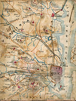
Arlington Ridge is an neighborhood in Arlington County, Virginia, United States. It is bordered on the north by The Pentagon, on the west by the Army Navy Country Club, and on the south the City of Alexandria. The main thoroughfare is the eponymous Arlington Ridge Road, a mansion-lined boulevard that, due to its high elevation, offers picturesque views of Washington, D.C., and the surrounding areas. Also known simply as "The Ridge", this community is home to two historical points of interest: the Hume School (National Register of Historic Places), currently the site of the Arlington Country Historical Society and Museum, and Fort Scott (Historic District), currently the site of Fort Scott Park.

Excerpt from the Wikipedia article Arlington Ridge, Virginia (License: CC BY-SA 3.0, Authors, Images).

Arlington Ridge, Virginia
South Arlington Ridge Road, Arlington

Geographical coordinates (GPS) Address Nearby Places
placeShow on map

Wikipedia: Arlington Ridge, VirginiaContinue reading on Wikipedia

Geographical coordinates (GPS)

Latitude Longitude
N 38.853055555556 ° E -77.068333333333 °
placeShow on map

Address

South Arlington Ridge Road 2303
22202 Arlington
Virginia, United States
mapOpen on Google Maps

Arlington Ridge Neighborhood Sign
Share experience

Nearby Places

Aurora Highlands Historic District

The Aurora Highlands Historic District is a national historic district located at Arlington County, Virginia. It contains 624 contributing buildings, 2 contributing sites, and 1 contributing structure in a residential neighborhood in South Arlington. Aurora Highlands was formed by the integration of three subdivisions platted between 1896 and 1930, with improvements in the form of modest single-family residences. The district is characterized by single family dwellings with a number of twin dwellings and duplexes, three churches, a rectory, two schools, two landscaped parks, and commercial buildings. The oldest dwelling is associated with “Sunnydale Farm” and is a Greek Revival-style dwelling built about 1870. The predominant architectural style represented is Colonial Revival.In the early 1970s, spillover commuter parking in Aurora Highlands by workers at the adjacent Crystal City complex led the county to establish the first residential zoned parking in the U.S. with the goal of reducing air pollution and protecting the neighborhood character as well as its quality of life. A lawsuit was filed to block it as a violation of the Equal Protection Clause of the Fourteenth Amendment. The plaintiffs prevailed in trial court and then on appeal to the Virginia Supreme Court, which held it unconstitutional since it granted residents of the permit zone greater rights over the public streets than their neighbors outside of it. The county appealed to the U.S. Supreme Court, which reversed the lower courts in Arlington County Board v. Richards, holding that discrimination based on residency alone was not unconstitutional if it rationally furthered a legitimate state interest such as those embraced by the ordinance.It was listed on the National Register of Historic Places in 2005.

Fort Scott (Arlington, Virginia)

Fort Scott was a detached lunette constructed in May 1861 to guard the south flank of the defenses of Washington during the American Civil War. It was named for General Winfield Scott, who was then General-in-Chief of the Union Army. An historic marker and a small remnant of the fort are the only evidence of the site of the fort on the grounds of what is now Fort Scott Park in Arlington County, Virginia. The fort was one of the ring of Union Army fortifications that the Union Army constructed as part of the Civil War defenses of Washington (see Washington, D.C., in the American Civil War). It was one of 33 forts on the Virginia side of the Potomac River that made up a defense line (the Arlington Line) for the national capital city. The fort was built with a perimeter of 313 yards enclosing emplacements for eight guns, two magazines, a guard house and bombproof. Armament at one time included five 24-pounders, one 8" howitzer, one 30-pounder Parrott rifle, one 6-pounder and two 10" mortars. A May 17, 1864, report from the Union Army's Inspector of Artillery noted the following: Fort Scott, Major Trumbull commanding.–Garrison, one company First Connecticut Heavy Artillery–4 commissioned officers, 1 ordnance-sergeant, 137 men. Armament, two 12-pounder mountain howitzers, two 6- pounder James (rifled). Magazines, two; dry and in good condition. Ammunition, full supply and serviceable. Implements, complete. Drill in artillery, fair. Drill in infantry, fair. Discipline, fair. Garrison sufficient for the work." Construction of the defense of Alexandria to the west subsequently reduced the importance of the fort. The fort was abandoned in 1865 at the end of the war. The fort is located in the Arlington Ridge community.

Fort Richardson (Arlington, Virginia)

Fort Richardson was a detached redoubt that the Union Army constructed in September 1861 as part of the Civil War defenses of Washington (see Washington, D.C., in the American Civil War). The Army built the fort shortly after its rout at the First Battle of Bull Run (Manassas) in late July 1861. The Army named the fort after General Israel B. Richardson, whose division had been deployed to defend the City of Washington against attack by way of the Columbia Turnpike.The structure, which was the highest fortification on the Arlington Line, occupied a commanding position on the crest of a ridge. It had a perimeter of 316 yards and emplacements for 15 guns, including a 100-pound Parrott rifle that could sweep a sector from Fort Ellsworth to Fort DeKalb (later named Fort Strong). The fort housed bomb-proofs and two ammunition magazines, and was adjacent to a military encampment. A May 17, 1864, report from the Union Army's Inspector of Artillery (see Union Army artillery organization) noted the following: Fort Richardson, Major Trumbull commanding.–Garrison, three companies First Connecticut Heavy Artillery–1 major, 12 commissioned officers, 1 ordnance-sergeant, 412 men. Armament, two 24-pounder field howitzers, six 24-pounder siege (smooth), one 100-pounder rifled Parrott, three 30-pounder rifled Parrotts, two 24-pounder Coehorn mortars, one 10-inch mortar. Magazines, two: dry and in good order. Ammunition, full supply and serviceable. Implements, complete and in good order. Drill in artillery, fair. Drill in infantry, fair. Discipline, fair. Garrison sufficient for the work. After the Civil War ended in 1865, the United States Army returned many of the properties that contained its fortifications in the Washington, D.C., area to the properties' rightful owners. In some instances, the Army compensated the owners for the use of the properties and for damages that had resulted from the Army's wartime activities. In addition, the Army sold at auction many of the fortifications' materials.The remnants of Fort Richardson are presently located on the grounds of the Army Navy Country Club in Arlington County, Virginia. The fortification's earthen south wall and ditches are well-preserved. A historic marker that the Arlington County government erected in 1965 stands along the Country Club's private access road (Memorial Drive) alongside the remnants of the fort.