Sha Tin
Cities in AsiaNew TerritoriesRestricted areas of Hong Kong red public minibusSha TinUrban areas ... and 1 more
Use Hong Kong English from April 2019

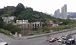
Sha Tin, also spelt Shatin, is a neighbourhood along Shing Mun River in the eastern New Territories, Hong Kong. Administratively, it is part of the Sha Tin District. Sha Tin is one of the neighbourhoods of the Sha Tin New Town project. The new town was founded in 1973 under the New Towns Development Programme of the Hong Kong government. Its current name was named after the nearby village of Sha Tin Wai. The literal English translation is 'Sand Fields'.
Excerpt from the Wikipedia article Sha Tin (License: CC BY-SA 3.0, Authors, Images).Sha Tin
Che Kung Miu Road,
Geographical coordinates (GPS) Address Nearby Places Show on map
 Continue reading on Wikipedia
 Geographical coordinates (GPS)
| Latitude | Longitude |
|---|---|
| N 22.375 ° | E 114.18333333333 ° |
Address
車公廟路 Che Kung Miu Road
Che Kung Miu Road
Hong Kong, China
Open on Google Maps