place

Jørstadmoen

Innlandet geography stubsLillehammerPopulated places on the GudbrandsdalslågenVillages in Innlandet
Jørstadmoen
Jørstadmoen

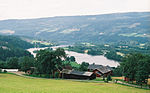
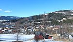
Jørstadmoen is a village in Lillehammer Municipality in Innlandet county, Norway. The village is located along the river Gudbrandsdalslågen, about 4 kilometres (2.5 mi) to the northwest of the town of Lillehammer. The 0.8-square-kilometre (200-acre) village has a population (2021) of 661 and a population density of 825 inhabitants per square kilometre (2,140/sq mi).The village is the site of the Jørstadmoen leir, a military base that is the main base for the Norwegian Cyber Defence Force as well as the Cyber Engineer Academy. The village also has a school, grocery store, and sports facilities.

Excerpt from the Wikipedia article Jørstadmoen (License: CC BY-SA 3.0, Authors, Images).

Jørstadmoen
Kastrudvegen, Lillehammer

Geographical coordinates (GPS) Address Nearby Places
placeShow on map

Wikipedia: JørstadmoenContinue reading on Wikipedia

Geographical coordinates (GPS)

Latitude Longitude
N 61.14558 ° E 10.38458 °
placeShow on map

Address

Kastrudvegen

Kastrudvegen
2625 Lillehammer
Norway
mapOpen on Google Maps

Jørstadmoen
Jørstadmoen
Share experience

Nearby Places

14th World Scout Jamboree

The 14th World Scout Jamboree was held July 29 to August 7, 1975, and was hosted by Norway at Lillehammer, on the shore of Lake Mjøsa.King Olav V and Harald V of Norway, who then was crown prince, opened "Nordjamb '75", as it became popularly known, in the presence of 17,259 Scouts from 94 countries. The slogan was Five Fingers, One Hand, an example of international cooperation on the part of the five Nordic countries responsible for its organization.This slogan stood symbolically for: Five fingers separately are small and weak, but together form an efficient and strong unit Scouts from all five continents meet at the World Jamboree The five Nordic countries jointly host a world eventThe slogan for the Jamboree was represented in a number of ways, including one event that brought all of the Jamboree participants together into the central arena, where they formed a giant hand that was photographed from aircraft flying overhead.The British contingent, led by Robert Baden-Powell, 3rd Baron Baden-Powell, included Scouts from Branches in Bermuda, Hong Kong and Rhodesia.The program of this Jamboree included excursions in the mountains by international patrols, activity areas, Nordic trail, choir, visit to Maihaugen cultural museum, and the Jamboree Country Fair. Home hospitality was provided in residences across scandanavia. This Jamboree included in the program several activities involving modern technology, as well as hiking, orienteering and camping.The Jamboree was also visited by Carl XVI Gustav of Sweden and Crown Prince Mohammed VI of Morocco.

Gudbrandsdalen
Gudbrandsdalen

Gudbrandsdalen (Urban East Norwegian: [ˈɡʉ̂ː(d)brɑnsˌdɑːɳ]; English: Gudbrand Valley) is a valley and traditional district in the Norwegian county of Innlandet (formerly Oppland). The valley is oriented in a north-westerly direction from Lillehammer and the lake of Mjøsa, extending 230 kilometers (140 mi) toward the Romsdalen valley. The river Gudbrandsdalslågen (Lågen) flows through the valley, starting from the lake Lesjaskogsvatnet and ending at the lake Mjøsa. The Otta river which flows through Otta valley is a major tributary to the main river Lågen. The valleys of the tributary rivers such as Otta and Gausa (Gausdal) are usually regarded as part of Gudbrandsdalen. The total area of the valley is calculated from the areas of the related municipalities. Gudbrandsdalen is the main valley in a web of smaller valleys. On the western (right hand) side there are long adjacent valleys: Ottadalen stretches 100 kilometers (62 mi) from Otta village, Gausdal some 50 kilometers (31 mi) from Lillehammer and Heidal some 40 kilometers (25 mi) from Sjoa. Gudbrandsdalen runs between the major mountain ranges of Norway including Jotunheimen and Dovrefjell–Rondane.Together with the Glomma river and the Østerdalen valley, the river Lågen and the Gudbrandsdalen valley form Norway's largest drainage system covering major parts of Eastern Norway. Gudbrandsdalen is home to Dovre Line railway and the European route E6 highway. The valley is the main land transport corridor through Eastern Norway, from Oslo and central eastern lowlands to Trondheim and Møre og Romsdal. The valley is divided into three parts: Norddalen (Northern valley; the municipalities of Lesja, Dovre, Skjåk, Lom, Vågå and Sel), Midtdalen (middle valley; the municipalities of Nord-Fron, Sør-Fron and Ringebu), and Sørdalen (Southern valley; the municipalities of Øyer, Gausdal and Lillehammer). The municipalities within the valley fall under the Vestre Innlandet District Court. Until 2016, the valley was also a police district. The Gudbrandsdalen district covers about 60% of the former Oppland county.The main character in Henrik Ibsen's play Peer Gynt was inspired by a real or legendary person living in the valley in the 18th or 17th century. Ibsen travelled through the valley in 1862 and collected local stories, legends and poems. Ibsen also made drawings from his trip, including "Elstad in Gudbrandsdalen".