place

Osbaldeston

Civil parishes in LancashireGeography of Ribble ValleyLancashire geography stubsUse British English from April 2015Villages in Lancashire
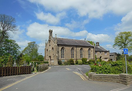
St Mary's Church, Osbaldeston

Osbaldeston is a village and civil parish in Lancashire, England about 3+1⁄4 miles (5.2 km) north-west of Blackburn and 7 miles (11.3 km) east of Preston. The population of the civil parish as taken at the 2011 census was 185.Osbaldeston is on the A59 road and lies on the south bank of the River Ribble opposite Ribchester. The parish has an area of 1,084 acres (1.7 sq mi), and the land rises from 70 ft above sea level, by the banks of the river, to 360 ft to the south-east. There is no Anglican place of worship, but the Roman Catholic Church of St. Mary (built in 1837–38) is at grid reference SD648318 in Longsight Road and is Perpendicular in style. The hamlet of Osbaldeston Green lies due north of the village. There is record of a Roman Road in the area.Osbaldeston Hall, which lies beside the Ribble, is a Grade II* listed building dating from about 1600, constructed with crucks. It is associated with the Catholic martyr Edward Osbaldeston. Oxendale Hall is a building of 1656, with a gabled façade. The hall has two stories, and most of the house has a Snecked masonry façade from a 1946 restoration. This was performed after a long period of time when many parts of the hall, which was used as a farmhouse, fell into dilapidation. Much of the inside of the house, including the 'banqueting hall', has visible timber framing.

Excerpt from the Wikipedia article Osbaldeston (License: CC BY-SA 3.0, Authors, Images).

Osbaldeston
Osbaldeston Lane, Ribble Valley Osbaldeston

Geographical coordinates (GPS) Address Nearby Places
placeShow on map

Wikipedia: OsbaldestonContinue reading on Wikipedia

Geographical coordinates (GPS)

Latitude Longitude
N 53.782 ° E -2.538 °
placeShow on map

Address

Osbaldeston Lane

Osbaldeston Lane
BB2 7JB Ribble Valley, Osbaldeston
England, United Kingdom
mapOpen on Google Maps

St Mary's Church, Osbaldeston
Share experience

Nearby Places

Mellor, Lancashire
Mellor, Lancashire

Mellor is a village situated in the Borough of Ribble Valley in Lancashire, England. The population of the civil parish at the census of 2011 was 2,262.It is reasonably large in size for a village, with two churches, one Church of England Parish Church (St Mary's) and one Methodist, as well as a primary school, three public houses and a hotel. In addition to this there is a post office and general store, a hair salon and a beauty salon, a high quality butcher's shop, a pharmacy and a private hire company. There are also three disused quarries, and the remains of an eel farm, that was destroyed by fire in the 1990s. Stanley House is a 16th Century building which is listed on the English Heritage Register. It is now a hotel and spa. Atop the highest hill on Mellor Moor, overlooking the village, is the site of a Roman signalling station, and a now disused Royal Observer Corps Nuclear Blast and Fallout Monitoring Station. The monitoring post was opened in July 1959, was decommissioned in October 1968, and is situated on a low mound ten yards west of a trig point overlooking BAE Samlesbury Airfield. Many people still believe that this was a nuclear shelter or an air raid shelter for the use of the local population during times of war. A millennium viewpoint pillar has been erected alongside encroaching onto the top of the post. Mellor has a village hall, situated near the centre of the village. It hosts many activities such as football, tennis, bowls and hockey. The hall is also used for other activities such as line dancing, disco parties and exercise classes. The hall is available for hire. The hall also functions as the community centre for the village, where residents can go to discuss how to improve the local area. Close to the village hall is a playing field and a tennis court, which proves very popular in the summer. In the centre of the village, there is a playground adjacent to a small public library, and a doctor's surgery, which share the same building. The local populace is generally middle class and middle aged, although the tranquil rolling hills and tight sense of community have made it a prime retirement location. Mellor is linked to Mellor Brook, another small village, which features a bakery, post office with general store, an art gallery and the Feildens Arms, a public house. The hub of Mellor Brook is the Community Centre, which was originally a chapel before becoming a primary school, which closed in 1962. In 1966, the building became a Community Centre, having been bought from the church, to be maintained as a Registered Charity until this day.

Mellor Brook
Mellor Brook

Mellor Brook is a village which straddles the borders of the Boroughs of Ribble Valley and South Ribble in Lancashire, England. The village population at the 2011 census was 2,467.The village of Mellor Brook is approximately 4 miles (6 km) north west of Blackburn. The geographical area of Mellor Brook is quite small, covering an area of approximately 4 square miles (10 km2). There is a bakery located in the heart of Mellor Brook. The bakery is well known and successful and started in the village, eventually moving its main operation to nearby Ramsgreave, but still retaining its original village shop. The shop's pies are a favourite of the English fashion designer, Wayne Hemingway. In recent years, both the village's newsagent and post office have closed. In 1808/9, the road (A59) from Mellor Brook to Clitheroe was opened as a toll road hence the position of the toll house at the top of Higher Commons Lane. Preston New Road (A677) between Blackburn and Preston, followed in 1824 and hence Branch Road, getting its name because it joined the two turnpike roads, opened at the same time. The village also has a thriving community centre; it is thought the building came into existence in June 1823, when a plot of land was assigned to a group of gentlemen on which they could build an independent place of worship. The building was purchased by the Church of England in 1833 and it was proposed that it be used during the week as a schoolhouse. The premises became known as St Saviours Chapel, Mellor Brook. The building was used as a primary school right until 1962, after which time the Church allowed it to be sold to the parish councils of the area. In 1966, Mellor Brook Community Centre came into existence, and has been such ever since. The village is adjacent to the former Samlesbury Aerodrome, now owned by BAE Systems. BAE developed commercial units on the site close the village.