Oyster Harbour, Western Australia

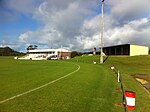
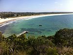
Oyster Harbour is a permanently open estuary, north of King George Sound, which covers an area of 15.6 square kilometres (6 sq mi) near Albany, Western Australia. The harbour is used to shelter a fishing fleet carrying out commercial fishing and the farming of oysters and mussels via a dredged channel around Emu Point to the Emu Point Boat Pens. A significant number of waterbirds use the harbour for feeding. The place is currently a family tourist center. Oyster Harbour is fed by the King and Kalgan Rivers and discharges into King George Sound. A planned locality of Oyster Harbour on the Lower King Road is under construction with 2,300 home sites.At the north eastern end near the mouth of the Kalgan River mouth are the Albany Fish Traps, a site of great significance to the local Mineng peoples, constructed over 7,500 years ago.
Excerpt from the Wikipedia article Oyster Harbour, Western Australia (License: CC BY-SA 3.0, Authors, Images).Oyster Harbour, Western Australia
Swarbrick Street, Albany Emu Point
Geographical coordinates (GPS) Address Nearby Places Show on map
 Continue reading on Wikipedia
 Geographical coordinates (GPS)
| Latitude | Longitude |
|---|---|
| N -34.993858333333 ° | E 117.94439166667 ° |
Address
Swarbrick Street
Swarbrick Street
6332 Albany, Emu Point
Western Australia, Australia
Open on Google Maps